


Contents
Scroll to:
https://doi.org/10.18599/grs.2025.4.21
Scroll to:
The sedimentary cover of the Russian Eastern Arctic, which includes the Laptev, East Siberian and partly Chukchi Seas, is considered one of the most prolific oil and gas provinces. However its petroleum potential is difficult to assess due to the lack of wells that can provide data on the presence and quality of the source rocks within the area. To address this issue, the paleogeographic conditions for the development of the main sedimentary complexes have been restored. Investigations based on the paleogeographic reconstruction and available geochemical data from surrounding areas indicate a high probability of source rock presence in the Upper Cretaceous, Paleocene-Eocene, and Oligocene-Early Miocene units of the sedimentary cover. These speculative source rocks have been studied through numerical modeling, to assess their maturity, transformation ratio and generation potential. This results in delineating probable hydrocarbon kitchens within the Eastern Arctic shelf. The findings obtained provide a conceptual basis for further evaluation of oil and gas prospects, zoning of the studied area, and effective planning of geological exploration activities.
Lavrenova E.A. The Forecast and Assessment of Source Rocks Generation Potential in the Sedimentary Cover of the Eastern Arctic. Georesursy = Georesources. 2025;27(4):177-191. https://doi.org/10.18599/grs.2025.4.21
The Eastern Arctic’s subsurface contains significant hydrocarbon potential, albeit challenging to explore and geologically study. Successful development of this territory is only possible with highly effective geological exploration, which is supported by a robust geological framework, including petroleum systems (PS) models.
Source rocks (SR) are key elements of PS (Magoon, Dow, 1994) and largely determine their hydrocarbon potential. The distribution of source rocks and their initial geochemical characteristics are controlled by depositional settings. The realization of the source rocks’ generation potential depends on the tectonic and thermal regimes of the basin. The presence of SR in the sedimentary cover of the Eastern Arctic is accepted by many researchers who, relying on geochemical data from adjacent land, estimate their hydrocarbon potential (Grushevskaya, Uvarova, 2020; Evdokimova et al., 2007; Polyakova et al., 2017; Stupakova et al., 2017). However, in the absence of a 3D geological model of the sedimentary cover, providing a reasonable extrapolation of the geochemical properties of rocks, the reliability of such a prediction is low.
Clearly, the lack of deep drilling within the Eastern Arctic significantly complicates mapping of SRs within the sedimentary cover. However, using a regional structural model, paleogeographic reconstructions, and data on the geochemical characteristics of rocks on adjacent onshore, it is possible to predict their distribution and properties within the sedimentary cover. Subsequently, using numerical modeling, we can reconstruct their thermal evolution and the realization of their generation potential. This methodological approach was applied in this study, the purpose of which is to evaluate the hydrocarbon potential of probable SRs within the sedimentary cover of the East Arctic shelf. The main tasks to be solved included: identifying in the sedimentary section and constructing maps of the geochemical characteristics of the predicted oil and gas source strata, reconstructing their thermal evolution, assessing the volumes of generated and emigrated hydrocarbons, studying the uncertainties in the thermal regime of sedimentary basins on the realization of the generation potential of the studied SR, and identifying pods of active source rocks.
The study area encompasses the East Siberian, Chukchi, and Laptev Seas (Fig. 1). The East Arctic offshore areas belong to the shelf region of the Arctic Ocean, bordered to the north by the Eurasian and Amerasian basins. The former is a basin of oceanic crust and is a continuation of the Atlantic rift system. The crustal nature of the Amerasian Basin remains controversial.
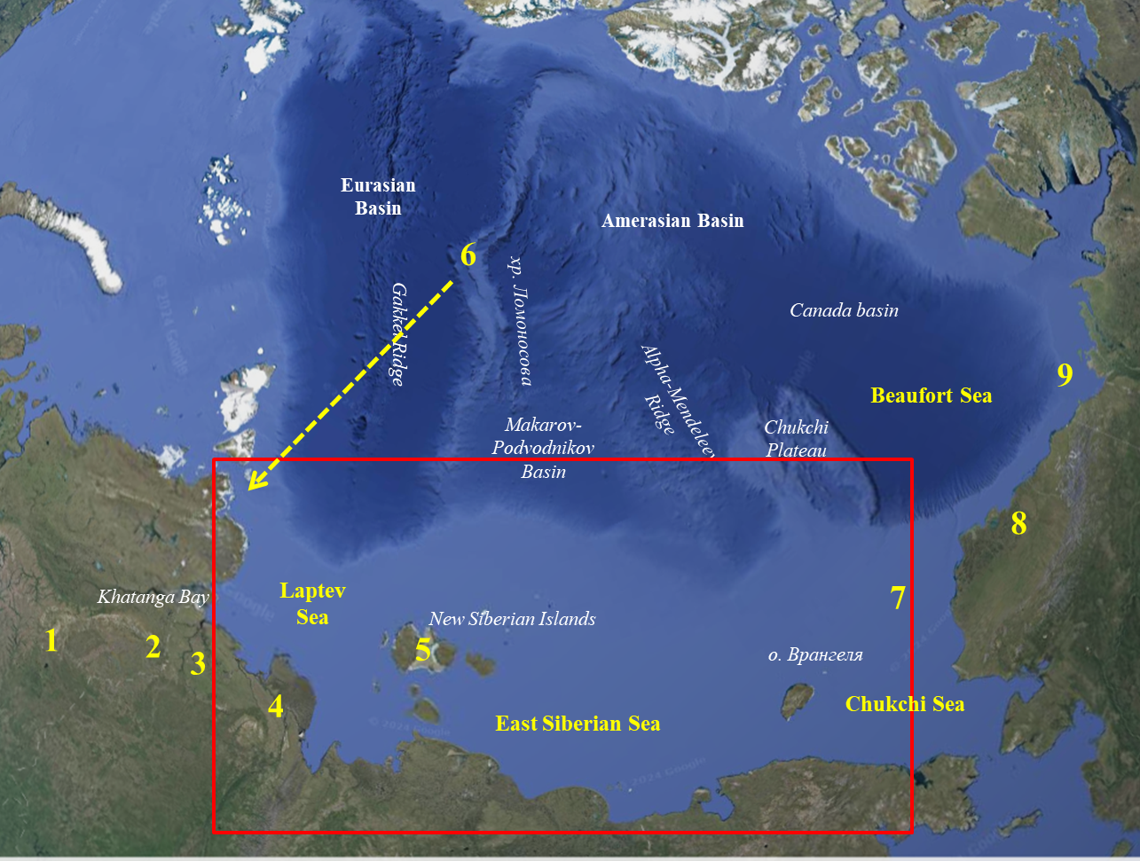
Fig. 1. Location map of data points for geochemical studies of Mesozoic and Cenozoic deposits in the East Arctic: 1 – Yenisei-Khatanga Trough, 2 – Lena-Anabar Trough and Anabar-Khatanga Saddle, 3 – Olenek Zone, 4 – Lena River delta, 5 – Kotelny Island, 6 – ACEX boreholes, 7 – exploration wells in the US Chukchi Sea sector, 8 – North Slope of Alaska, 9 – Mackenzie River delta. The study area is indicated by the red rectangle.
The East Arctic offshore areas are poorly studied. The shelves of the Russian sector have been studied primarily using geophysical (gravimetric, magnetometric, and seismic) methods. In total, the shelf area under study covers approximately 2.7 million square kilometers. Using federal budget funds, service companies JSC MAGE, JSC Sevmorneftegeofizika, JSC Dalmorneftegeofizika, JSC Soyuzmorgeo, and JSC Rosgeologiya completed 166,313 linear kilometers of 2D seismic, including 112,883 linear kilometers in the Laptev Sea. The majority seismic data has been acquired over the past 10 years using modern methods and technologies, ensuring the high fidelity of the collected geological information. Currently, the main uncertainties in the geological model stern form the absence of deep exploration wells on the shelf, which, in turn, hampers seismic-stratigraphic correlation, the prediction of lithofacies distribution, and the assessment of the basins’ thermal evolution.
The sedimentary cover within the study area includes four major sedimentary complexes: Aptian-Upper Cretaceous, Paleocene-Eocene, Oligocene and Miocene-Quaternary, separated by regional unconformities correlated with global tectonic events: the collision of the Siberian platform and the Alaska-Chukotka microcontinent (pre-Adaptian unconformity), rifting in the Makarov-Podvodnikov Basin (at the turn of the Cretaceous and Paleogene), rifting (at the turn of the Eocene and Oligocene) and the onset of post-rift subsidence (at the beginning of the Miocene) in the Eurasian Basin (Lavrenova et al., 2024).
The sedimentary cover, studied in outcrops on the islands and onshore areas, as well as in shallow boreholes, consists of terrigenous sequences deposited in shallow-marine and terrestrial environments.
This study builds upon a previously developed numeric 3D model of the sedimentary cover formation in the East Arctic (Lavrenova et al., 2024; Fig. 2). Its structural framework is defined by unconformities that subdivide the sedimentary cover into four major structural-stratigraphic units (model layers): Aptian–Upper Cretaceous, Paleocene–Eocene, Oligocene, and Miocene–Quaternary. The model encompasses the offshore areas of the Laptev, East Siberian, and Chukchi seas. Its structural framework consists of surface grids with a 1 × 1 km resolution. In the current research, the model was utilized for backstripping analysis, as well as for identifying and studying the stages and subsidence rates of depocenters. It also enabled the calculation of organic matter maturity for potential source rocks, and the evaluation of hydrocarbon generation and expulsion processes, incorporating numerical basin and petroleum system modeling technologies.
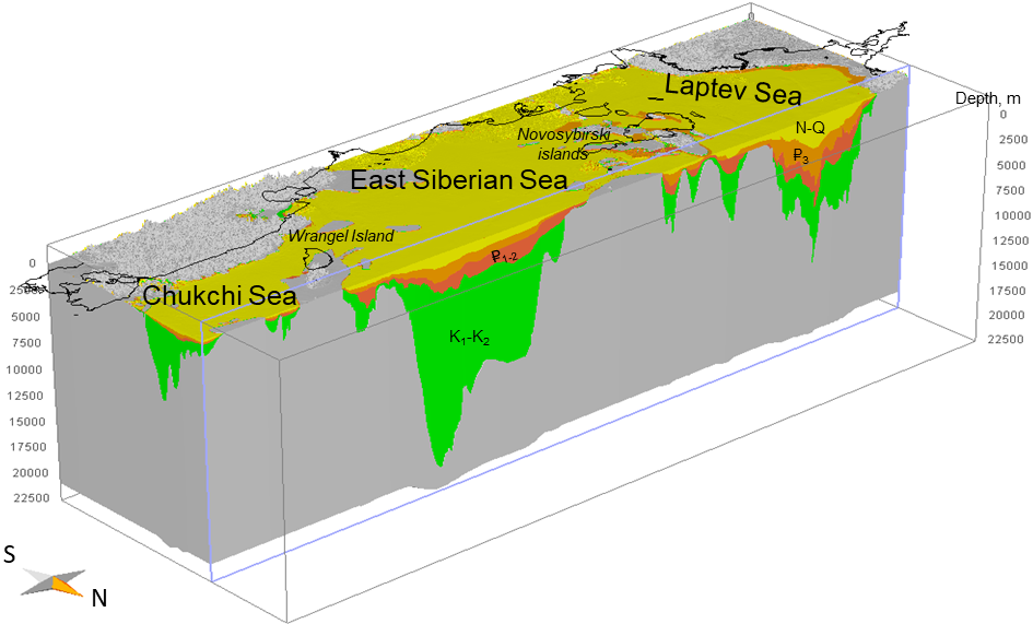
Fig. 2. Numeric 3D model of the geological framework of the East Arctic offshore sedimentary cover. The primary sedimentary units include the Aptian–Upper Cretaceous (K1–K2), Paleocene–Eocene (₽1–2), Oligocene (₽3), and Miocene–Quaternary (N–Q) deposits, modified from (Lavrenova et al., 2024).
In the absence of deep drilling wells within the offshore areas, regional paleogeographic reconstructions serve as a cornerstone for predicting depositional environments and the lithological composition of the sediments. The geological basis for facies maps included isopach maps of the major sedimentary sequences (Lavrenova et al., 2024), geological mapping data from adjacent islands and continental lands, and results from lithological and faunal analyses of samples from wells and outcrops. Furthermore, 2D seismic data, along with published and archival records containing information on paleogeographic conditions within the study area, were integrated into the analysis (Backman, Moran, 2009; Palma et al., 2021; Polyakova et al., 2013; Polyakova et al., 2017; Morrell et al., 1995; Stein et al., 2006; Stein, 2007; O’Regan et al., 2008; Polyakova et al., 2013; Dixon et al., 2019; Houseknecht et al., 2016; Somme et al., 2018; Stoupakova et al., 2017).
The applied paleogeographic reconstruction methodology involves the preliminary identification of paleogeographic domains based on isopach map analysis. The core of this analysis is the assumption of available accommodation space formed prior to the onset of sedimentation of the stratigraphic unit being analyzed. This accommodation space is progressively reduced by sediment supply during the formation of the unit. Under conditions of compensated sedimentation, the thickness of the resulting deposits is directly proportional to the initial accommodation space. The spatial distribution of this space across the basin is determined by bathymetric variations and is thus controlled by depositional environments. Greater basin depths correspond to larger accommodation space. Typically, a basin features a distal, deep-water area containing one or more isometric depressions, which are identified by closed isopachs of increased thickness.
To a first approximation, the zero-isopach of the stratigraphic unit can be regarded as the paleo-shoreline, separating continental depositional environments from marine ones. Intermediate paleogeographic domains are situated between the deep-water region and the shoreline. Initially, their depths are estimated based on the assumption that sediment thickness is generally controlled by the initial basin depth. Uncertainty regarding depth estimation is reduced by integrating additional geological data (in this study, from published sources): direct analysis of coeval rocks from wells and outcrops, including grain-size, facies, microfaunal, palynological, mineralogical, and geochemical analyses. The locations of these data points are plotted on the preliminary paleogeographic map to verify the consistency between the thickness-based zoning and the rock-study results, followed by the necessary adjustment of the domain boundaries.
Seismic data are utilized as a proxy for the geological framework of the sedimentary section. Among the most informative and readily identifiable features of sedimentation observed on seismic profiles are clinoforms, which represent a basinward-prograding sediment wedge. Within the framework of the seismic facies analysis, the clinoform architecture of the studied unit was considered a diagnostic indicator of marine depositional environments. The height and internal geometry of the clinoforms (sigmoid, shingled, tangential oblique, parallel oblique, the presence or absence of unconformities in the bottomsets, etc.) were used to predict paleo-basin depth, hydrodynamic regimes, and the location of sediment source areas.
The prediction of source rock presence within the sedimentary cover of the Russian East Arctic seas was conducted based on published (Dixon et al., 2019; Polyakova et al., 2013; Moran et al., 2006; Stein et al., 2007; Morrell et al., 1995; Palma et al., 2021; Masterson et al., 2021; Peters et al., 2006, etc.) and archival geochemical data, integrated with the paleogeographic reconstructions developed in this study. The locations of the areas where geochemical properties were studied are shown in Fig. 1. Most of these sites are situated outside the immediate study area. Extrapolation of geochemical characteristics was performed by accounting for basin affinity and paleogeographic settings. For instance, according to current geodynamic models, the Lomonosov Ridge is a continental block that rifted from the Barents-Kara margin during the Oligocene. This relationship justifies using the results from Cretaceous and Paleocene–Eocene deposits sampled in the ACEX (Arctic Coring Expedition) wells (Backman, Moran, 2009; Stein et al., 2006; Stein, 2007) to characterize the geochemical properties of rocks in the Taimyr-adjacent part of the Laptev Sea.
Basin modeling was performed using kinetic reactions for Type II and Type III kerogen (Burnham, 1989), consistent with the predicted geochemical characteristics of the organic matter in the studied source rocks. In the absence of data required to map the spatial distribution of source rock thickness, a uniform thickness of 50 m was assumed in the model. This value is considered a reasonable proxy based on empirical data from basins with proven source rocks. For example, the thickness of the Bazhenov Formation is approximately 50 m. While the total thickness of the Kuma Formation varies from 20 to 200 m, the thickness of its bituminous marl intervals typically ranges between 25 and 50 m. Similarly, within the Maikop Group source rocks, only the Khadum Formation is considered a prolific hydrocarbon producer, with thicknesses ranging from 50–80 m to 80–100 m depending on the region.
Direct heat flow measurements were not conducted within the study area; therefore, this parameter was estimated based on the geodynamic evolution of the basins (Lavrenova et al., 2024) and typical heat flow values associated with such regimes. Two distinct regions with potentially different thermal regimes were identified: the southern terminus of the Gakkel Ridge rift system, characterized by relatively elevated heat flow (70–75 mW/m²) typical of passive continental margins in the post-rift subsidence stage, and the remainder of the area within the young platforms of the Laptev and East Siberian seas, with a heat flow of approximately 60–65 mW/m².
To assess the impact of thermal regime uncertainties on the maturation of the generation potential of the source rocks, two scenarios were simulated: “Model A,” with heat flow variations of 60/70 mW/m², and “Model B,” with variations of 65/75 mW/m² for the platforms and the southern terminus of the rift system, respectively.
Within the scope of this study, the boundaries of pods of active source rock were delineated based on expulsion intensity maps (net expulsion per unit area) calculated as part of the current research. Specifically, the pods were defined as areas characterized by positive expulsion intensity values.
According to plate tectonic reconstructions (Dore et al., 2015), a major regression occurred in the Arctic in the mid-Cretaceous, caused by the closure of the South Anyui Ocean, accompanied by the collision of the Siberian Craton with the Kolyma-Omolon and Alaska-Chukotka microplates (Somme et al., 2018). Consequently, continental conditions developed over most of the study area in the second half of the Cretaceous. A large deep-water marginal marine basin, connected to the Canada Basin, was located in the northern part of the modern shelf of the East Siberian Sea (Somme et al., 2018).
The composition of Upper Cretaceous sediments within the East Arctic region has been studied in outcrops on adjacent island and continental landmasses, in boreholes on the southern coast of the Laptev Sea, in the American sector of the Chukchi Sea, and in the ACEX boreholes located on the Lomonosov Ridge.
From a paleographic perspective, the locations where rock composition was studied primarily characterize the continental and shallow-marine environments of Upper Cretaceous sediment accumulation, where they are represented predominantly by coarse-grained sediments: sands, sandstones, mudstones, and sandy clays (Moran et al., 2006). Of particular interest for predicting sedimentation environments in Late Cretaceous time are the results of studying Campanian sediments penetrated by the ACEX borehole, as before the opening of the Eurasian Basin (53–55 million years ago), the Lomonosov Ridge was part of the Eurasian continent (Moran et al., 2006). The Cretaceous rocks in the borehole are represented by dark clays, sandy at the base, which formed under coastal-marine anoxic settings (Stein, 2007).
At the regional level, paleogeographic conditions in the second half of the Cretaceous were not conducive to the formation of petroleum source sediments with good generation potential. The geochemical characteristics of Upper Cretaceous (Santonian-Coniacian) rocks formed in continental coastal lowland and shallow-marine environments were studied in shalow cores 3 (Houseknecht et al., 2016), located on the shelf of the Chukchi Sea. The sediments are represented by sands, silts, and tuffaceous mudstones with tuff interlayers and are characterized by low TOC (0.6%) and HI (17 mg HC/g rock). Rock-Eval parameters S1 and S2 are 0.03 and 0.1 mg HC/g rock, respectively. It has been established that the Cenomanian rocks of the Beaufort-Mackenzie Basin, which forms the apex of the Canada Basin, are source rocks (Dixon et al., 2019). These deposits (Boundary Creek, Smoking Hills, and Mason River formations) of small thickness, represented by clays with a high (up to 12%) organic matter content, were formed at the early stage of post-rift subsidence in distal outer shelf and slope settings with low sedimentation rates. I.D. Polyakova et al. provide the following geochemical characteristics of the Boundary Creek and Smoking Hills formations of early (MK1) maturity, containing mixed-type kerogen: the organic carbon content in the rocks varies from 2 to 7.8% with an average of 4.1%; the hydrogen index varies from 100 to 460 mg HC/g of rock with an average of 230; The pyrolytic index S1 is in the range from 0.9 to 3.1 mg HC/g rock (Polyakova et al., 2013).
According to R. Stein, immature Cretaceous rocks from the ACEX borehole studied using the Rock-Eval analisys contain 1–2% TOC, with a hydrogen index not exceeding 200 mg HC/g of rock. Based on a combination of geochemical indicators, the author classifies the rocks as potentially gas-generating with low potential (Stein, 2007).
At the end of the Cretaceous, rifting began in the Makarov-Podvodnikov Basin, leading to structural reorganization in the region and the formation of a regional unconformity, identified, among other things, in the ACEX boreholes. Sediments recovered at this boundary are represented by sandy clays and silty sands with sandstone inclusions. The sedimentation environments of the rocks correspond to shallow-marine proximal depositional environments. According to (Moran et al., 2006; Backman, Moran, 2009), citing (O’Regan et al., 2008), the portion of the Lomonosov Ridge in the borehole area was still part of the Eurasian continental margin during the Early Eocene, i.e., after the onset of rifting in the Eurasian Basin.
Based on a study of the faunal species composition and the material composition of sediments, K. Moran et al. characterize the marine basin in the Early Paleogene (late Paleocene to mid-Eocene) as warm, ice-free, subsaline, and biologically productive. During the Early Eocene, two hyperthermic events occurred in the Arctic Basin: PETM (Paleocene–Eocene Thermal Maximum, 55 Ma) and ETM2 (Eocene Thermal Maximum 2, 53 Ma). Sea surface temperatures during the Eocene Thermal Maximum (PETM) rose to 24 °C, compared to 18 °C immediately before and after the event. Equally important as the extreme warming is the evidence for the geographic isolation of the Paleogene Arctic Basin, which had a relatively humid climate. This evidence is based on plate tectonic reconstructions for this time and is supported by the presence of dark, organic-rich sediments in the sediments with fish remains, a species composition of dinoflagellates and siliceous microfossils, and the absence of traces of burrowing organisms and benthos. The observed facts indicate a semi-closed basin environment with estuarine circulation and short-term (possibly seasonal) fluctuations in fresh and subsaline conditions.
Towards the middle of the Eocene, the salinity of the Arctic Basin decreased significantly. The maximum freshening is associated with the short-term (0.8 Ma) “Azolla” event (Moran et al., 2006; Backman, Moran, 2009). This led to stratification of the water column with a freshened upper layer and a saline lower layer, which, in turn, caused seasonal or even perennial bottom hypoxia and anoxia (“euxine” conditions). Sedimentation rates during this time increased, presumably due to intensive river runoff and the supply of terrigenous material, amounted to 1–2 cm/Ma, which is an order of magnitude higher than modern rates in the central Arctic Ocean (Moran et al., 2006; Backman, Moran, 2009). The source of organic matter in Upper Paleocene mudstone sediments is primarily algae, whereas the organic matter of younger Early and Middle Eocene sediments was formed with the participation of higher vegetation. Sedimentary material accumulated in hydrodynamically calm, shallow-water environments, periodically under oxygen-deficient conditions, as evidenced by the presence of thin (a few millimeters) interbeds of black shales with high pyrite content (Stein et al., 2006; Stein, 2007).
At the beginning of the Eocene (approximately 49 million years ago), the basin is believed to have been characterized by fresh, relatively cool (10–14 °C) surface waters. The presence of freshwater in the Arctic at this time may have contributed to the formation of sea ice, which increased albedo and contributed to global cooling. Sedimentation patterns during this period favored the accumulation and preservation of organic carbon in sediments, including in shallow-water environments (Moran et al., 2006; Backman, Moran, 2009).
From the mid-Eocene onward, cooling began in the region; however, “euxine” conditions, resulting from highly stratified water, persisted until the early Miocene, when the Arctic Ocean ceased to be isolated due to the opening of the Fram Strait (Moran et al., 2006; Backman, Moran, 2009).
According to Stein et al. (2006), the Middle Eocene sediments in the ACEX boreholes have a dark gray-black color due to the elevated content (1–5%) of TOC. The highest concentrations (up to 14%) are observed in the lower part of the Miocene deposits, which lie intermittently on the underlying Eocene deposits. Based on the ratio of carbon and sulfur concentrations in the sediments, Stein concluded that “euxinian” conditions (vertical stratification of the salinity of the water column, accompanied by hypoxia and anoxia) in the basin began soon after the PETM event and continued for about 10 million years, during the early to middle Eocene. Moreover, samples analyzed from several black layers at the base of the Early Miocene are also characterized by “euxinian” accumulation conditions (Backman, Moran, 2009). Since “euxine” conditions characterize deposits on either side of the mid-Cenozoic hiatus spanning the Oligocene in the ACEX wells, J. Backman and K. Moran suggested that these conditions also existed during the time interval represented by the hiatus, thereby extending the duration of this period from 10 to 37 million years. Pyrolytic studies of samples from the ACEX wells showed that the organic carbon-rich mid-Eocene deposits possess good generation potential and are regarded as source rocks. However, based on measured Tmax and vitrinite reflectivity values, the rocks are immature (Stein, 2007).
Four intervals in the lower part of the Tertiary clinoform of the Beaufort-Mackenzie Basin, which formed in facies settings (delta plain, delta front, prodelta), according to (Morrell et al., 1995), can be considered potential SR for coeval reservoirs within the basin. Lithologically, these are prodelta clays that contain a significant admixture of organic matter of terrestrial origin. However, the rocks also contain kerogen in the form of resinite, which is capable of generating liquid hydrocarbons at the early stages of organic matter maturity. The TOC content in these deposits rarely exceeds 2%; however, the ability of Tertiary shelf clays to generate significant volumes of petroleum hydrocarbons has been demonstrated by the example of the Amauligak field, where the genetic relationship between oil reservoirs and Tertiary SR has been confirmed by biomarker analysis (Morrell et al., 1995).
According to I.D. Polyakova et al. (2013), Paleogene sediments of the Beaufort-Mackenzie Basin are characterized by good generation properties. Thus, Lower Paleogene sediments of the Fish River, Aklak, Taglu, and Richards formations at the early stage of maturity (PK-MK1) contain kerogen of type II or mixed type II/ III. The organic carbon content of the rocks varies from 2 to 8.5%, averaging 3.5%. The hydrogen index reaches 600 mg HC/g of rock, with an average value of 200 mg HC/g of rock. Furthermore, recent studies have shown that Paleogene source rocks are the primary source of hydrocarbons in the Sagavanirktok reservoir (Kuvlum 1 well) and the Canning and Franklinian formations (Stinson 1 well) on the North Slope of Alaska. Oil seeps from outcrops off the coast of Arctic National Park in the United States also contain biomarkers indicating a Tertiary source (Palma et al., 2021). Although Paleogene source rocks have not been studied in Alaska, the most likely SR is the Canning Formation (Canning Fm) shale sequence, which is composed of clays formed during periods of significant transgression (Palma et al., 2021). Moreover, the Tertiary sediments encountered by the Klondike well in the American sector of the Chukchi Sea are characterized by low TOC (approximately 1%) and contain type III kerogen. Geochemical studies have classified them as gas-generating strata with satisfactory to good potential.
In the Miocene, the opening of the Fram Strait in the Arctic Ocean caused a shift from reducing to oxidizing stasis. According to Backman et al. (2009), middle-to-upper Miocene deposits on the Lomonosov Ridge formed in oxidizing environments and contain little organic carbon, making them unsuitable as potential petroleum source rocks.
Considering the above, within the study area, potential SRs are predicted in sediment cover at three stratigraphic levels: the Upper Cretaceous, the Paleocene-Eocene, and the Oligocene-Miocene boundary.
As shown by the paleogeographic reconstructions conducted within the framework of this study, continental sedimentation settings, including areas of accumulation and denudation, as well as littoral (coastal, periodically flooded by the sea), predominated within the studied territory of the Eastern Arctic during the second half of the Cretaceous (Fig. 3A). Small, enclosed shallow basins likely existed in the central part of the Laptev Sea. The significant deep-sea Dremkhed-North Chukchi Basin was located in the northern part of the modern shelf of the East Siberian Sea. It is characterized by high sedimentation rates. The emerging accommodation space was compensated by significant volumes of sedimentary material arriving from the southwest, which ensured the rapid advance of the prograding sediment wedge in a northeasterly direction.
Based on available geochemical data (Polyakova et al., 2013) and current understanding of Late Cretaceous sedimentary basin evolution, it is suggested that source rocks containing mixed-type kerogen with significant oil-prone potential may have developed within the East Siberian Sea. These deposits likely formed in distal, relatively deep-water parts of the paleo-basin, specifically within the clinoform bottomsets. By analogy with the Beaufort-Mackenzie Basin, they may contain approximately 4% TOC with a Hydrogen Index (HI) of 230 mg HC/g rock. Furthermore, results from the ACEX boreholes (Stein, 2007) suggest that under anoxic conditions in restricted basins within the central Laptev Sea, gas-prone source rocks may occur, containing approximately 1% TOC with an HI of 150 mg HC/g rock (Fig. 4A).
During the Paleocene–Eocene, the land area decreased compared to the previous evolutionary stage, and sedimentation across much of the study area occurred under littoral conditions (Fig. 3B). The rates of accommodation space creation declined. However, the volume of sediment supply apparently remained significant, leading to the gradual infilling of depressions inherited from the Late Cretaceous stage and their subsequent fragmentation. Consequently, the deep-water Dreamkhead–North Chukchi Basin, which was a unified system in the Late Cretaceous, split into two shallow-water bodies. One of these, which maintained a connection to the open ocean, was located in the northern East Siberian Sea shelf, while the other formed a restricted basin west of the New Siberian Islands.
During the Oligocene, the sedimentation basin in the Laptev Sea segment deepened, forming an elongate, relatively deep-water area in its central part (Fig. 3C). Against the background of ongoing extension in the Gakkel Ridge rift zone, the basin deepened and was infilled by clinoform sequences north of the New Siberian Islands. Within the East Siberian shelf, which underwent post-rift subsidence following the completion of rifting in the Makarov and Podvodnikov basins, a shallow marginal sea was formed.
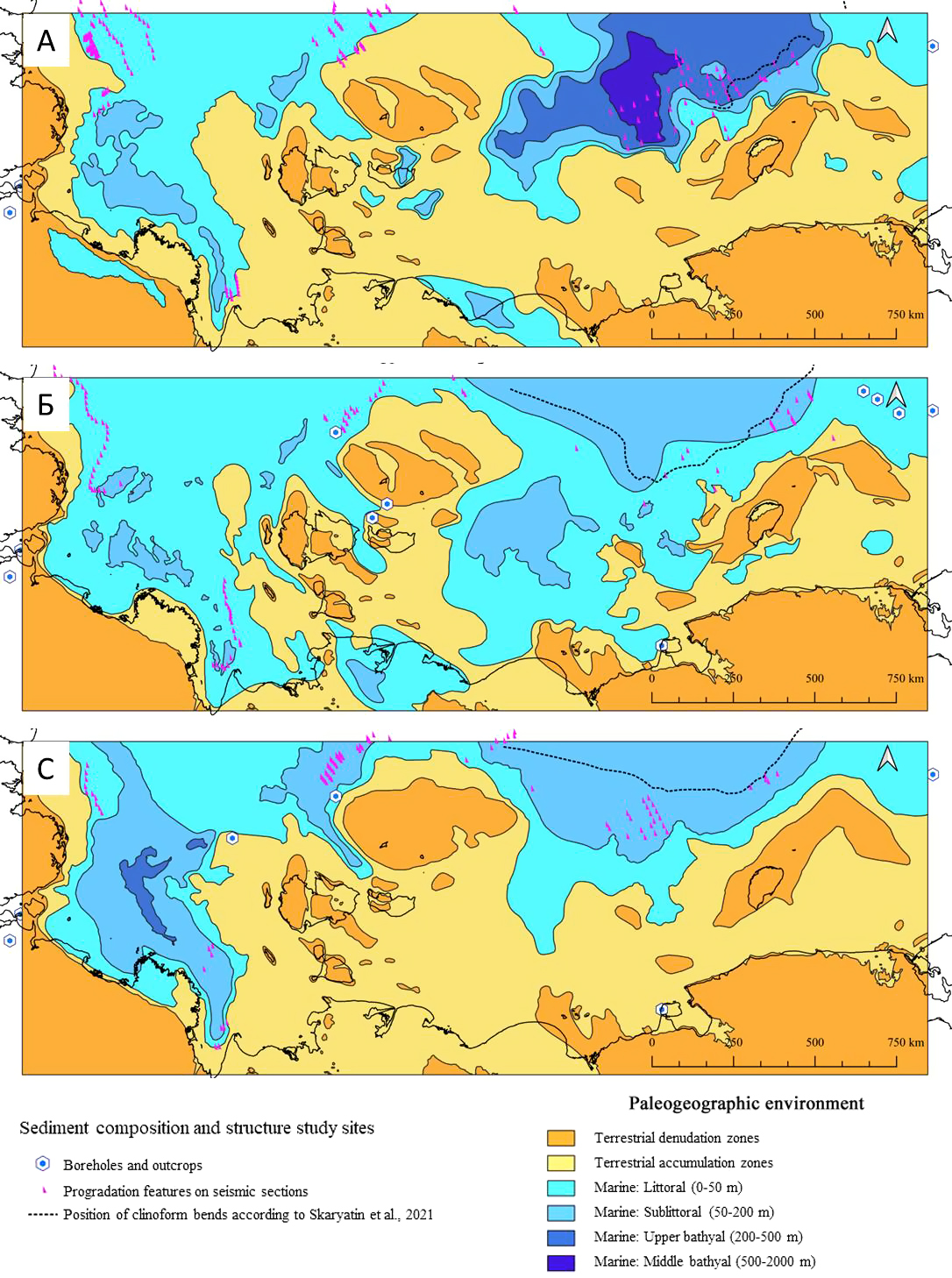
Fig. 3. Paleogeographic reconstructions for the following periods: A – Aptian–Late Cretaceous; B – Paleocene–Eocene; C – Oligocene
As demonstrated by Moran et al. (2006) and Backman and Moran (2009), the Arctic Ocean remained an isolated basin from the late Paleocene to the early Miocene. This isolation led to the widespread development of specific hydrochemical conditions, including water column stratification and anoxic (euxinic) environments. Such settings, coupled with high biological productivity, provided favorable conditions for the formation of source rocks with significant generation potential. The geochemical results presented in the previous section indicate that the Paleogene deposits serve as regional source rocks. Based on published data regarding the generation properties of Paleogene rocks and the results of our paleogeographic reconstructions, source rocks with a TOC of 2% and HI values of approximately 200 mg HC/g rock are predicted in coastal and shallow-water settings. In the sublittoral zone, an improvement in the geochemical characteristics of potential source rocks is expected, with TOC reaching 3% and HI up to 400 mg HC/g rock (Fig. 4B, C).
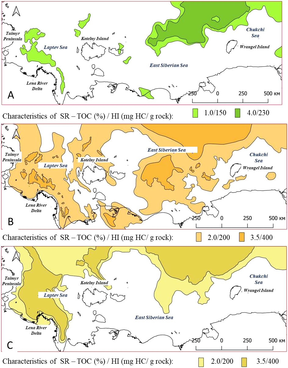
Fig. 4. Predicted source rock quality within the East Arctic offshore: A – Upper Cretaceous; B – Paleocene–Eocene; C – Upper Oligocene–Lower Miocene. Colors indicate areas of varying source rock quality.
The thermal evolution of the predicted source rocks was reconstructed, and their generation potential was evaluated (Figs. 5–8).
The organic matter (OM) of the Upper Cretaceous rocks, distributed across the central Laptev Sea and the northern East Siberian shelf, is characterized by high present-day maturity, corresponding to the MK4-MK5 stages (Fig. 5A-1, B-1). Currently, hydrocarbon generation is possible only along the margins of major depressions. Across most of the source rock distribution area, the generation potential has been fully exhausted (Fig. 5A-2, B-2). Two major pods of active source rock are predicted within the East Arctic study area: the “Laptev” and “East Siberian” pods. (Fig. 5A-3, B-3). Both are characterized by high present-day thermal maturity and a high transformation ratio of the generation potential.
Hydrocarbon expulsion commenced in the early Paleogene. In the East Siberian pod, this process dates back to the early Paleocene, while in the Laptev pod, it began in the early Eocene. The critical moment for the Upper Cretaceous source rocks was reached between the Eocene and the late Miocene in the East Siberian pod, and between the Oligocene and the late Miocene in the Laptev pod. Facies-driven variations in the geochemical properties of the Upper Cretaceous OM determined the differences in fluid types and the volumes of generated and expelled hydrocarbons. Specifically, the Laptev pod, which is expected to contain lean source rocks, is predicted to generate and expel primarily gaseous hydrocarbons in minor volumes – approximately 10 billion tons of fuel equivalent (Fig. 8). In contrast, the high-quality source rocks predicted in the East Siberian pod are capable of producing approximately 250 billion tons of fuel equivalent, predominantly (80%) liquid hydrocarbons (Fig. 8).
The predicted source rocks within the Paleocene–Eocene section are currently capable of generating both liquid and gaseous hydrocarbons across most of their distribution area (Fig. 6A-1, B-1). These rocks are characterized by a high transformation ratio of their initial generation potential (Fig. 6A-2, B-2). Hydrocarbon generation and expulsion processes commenced during the Oligocene, with the critical moment largely surpassed during the late Miocene.
Basin modeling results for the Paleocene–Eocene section identify three potential pods of active source rock: the “East Siberian”, “Laptev”, and “De Long” pods (Fig. 6A-3, B-3). The initial geochemical characteristics of the OM and the spatial extent of these pods determine the predicted hydrocarbon charge volumes (Fig. 8). Specifically, the large East Siberian and Laptev pods are expected to yield approximately 300 and 100 billion tons of fuel equivalent, respectively, while the De Long kitchen is estimated at 14 billion tons. Liquid hydrocarbons predominate in the fluid composition across all three pods.
The predicted source rocks within the Oligocene–Miocene boundary deposits are characterized by low thermal maturity and a low transformation ratio (Fig. 7A-1, B-1, A-2, B-2). Expulsion processes have only commenced within the northern Laptev Sea shelf, where a small pod is identified; according to our estimates, no more than 10 billion tons of fuel equivalent have expelled from this area (Fig. 8).
An investigation into the impact of input data uncertainties – specifically regarding heat flow – on the simulation results demonstrated that for overmature and highly mature source rocks, an increase in heat flow does not significantly affect the outcomes. In particular, the difference in generated and expelled hydrocarbon volumes between models with varying heat flow parameters does not exceed 10%.
At the same time, the Oligocene–Miocene source rocks, characterized by low thermal maturity, are highly sensitive to variations in this parameter: an increase in heat flow leads to a 40% rise in the volumes of generated and expelled hydrocarbons.
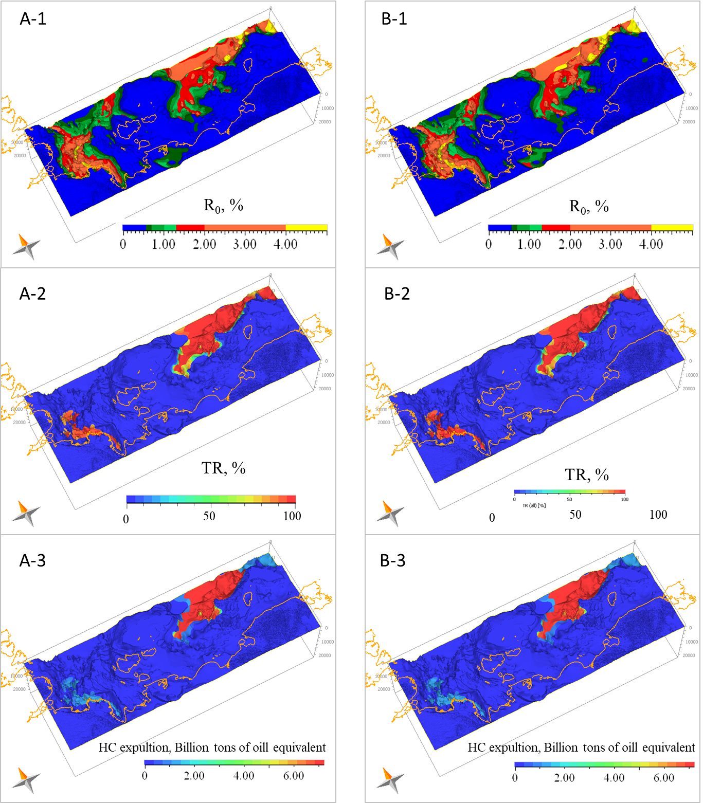
Fig. 5. Simulation results of the Upper Cretaceous source rock evolution under two heat flow scenarios: A – model with 60/70 mW/m² heat flow; B – model with 65/75 mW/m² heat flow. Calculated parameters: 1 – thermal maturity (R0); 2 – transformation ratio (TR); 3 – expulsion intensity.
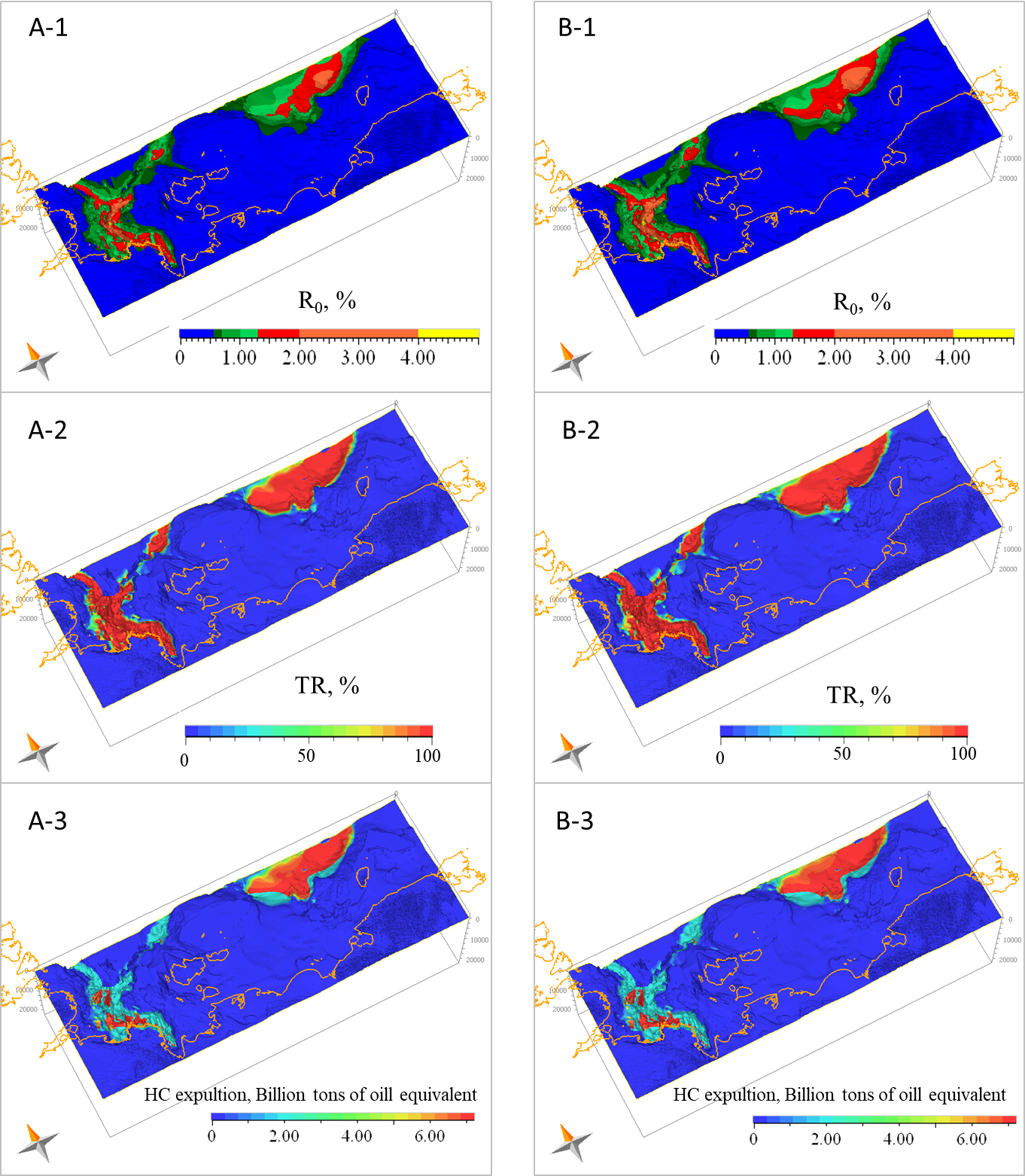
Fig. 6. Simulation results of the Eocene source rock evolution under two heat flow scenarios: A – model with 60/70 mW/m² heat flow; B – model with 65/75 mW/m² heat flow. Calculated parameters: 1 – thermal maturity (R0); 2 – transformation ratio (TR); 3 – expulsion intensity.
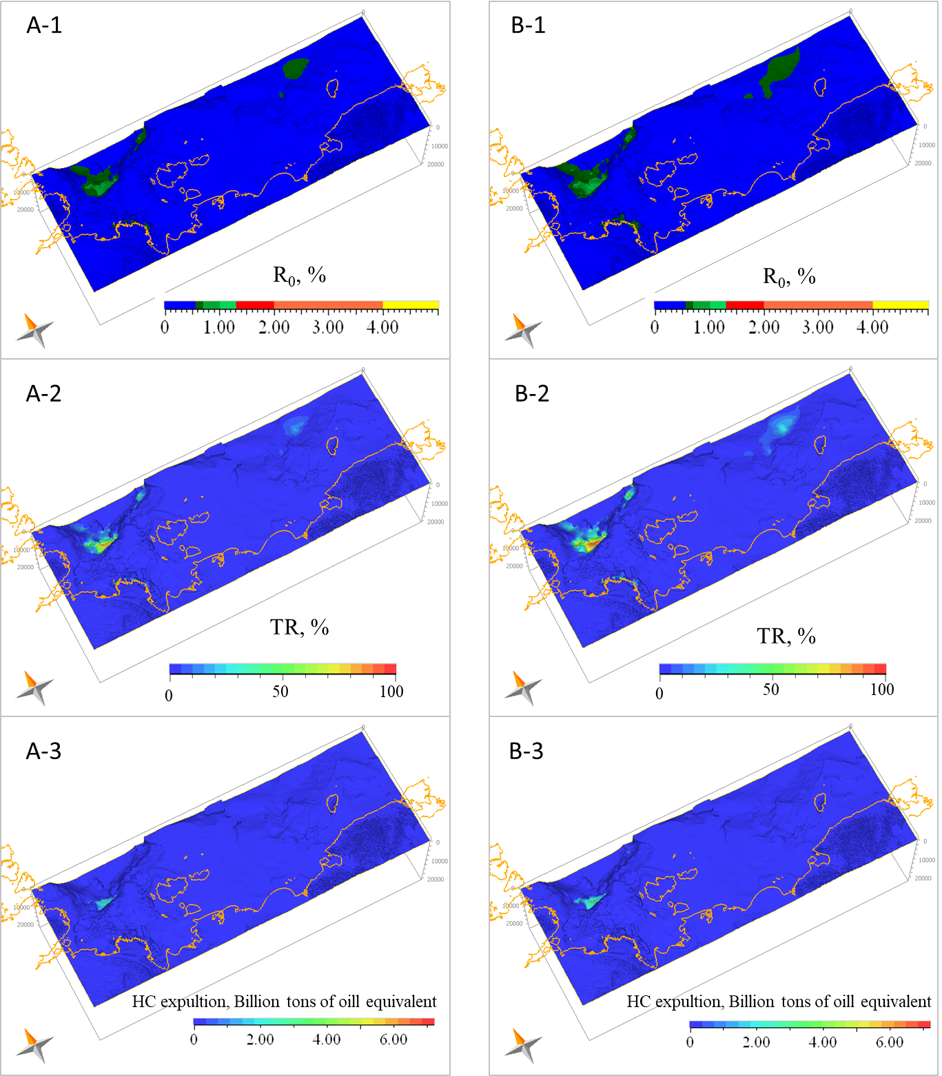
Fig. 7. Simulation results of the Oligocene source rock evolution under two heat flow scenarios: A – model with 60/70 mW/m² heat flow; B – model with 65/75 mW/m² heat flow. Calculated parameters: 1 – thermal maturity (R0); 2 – transformation ratio (TR); 3 – expulsion intensity.
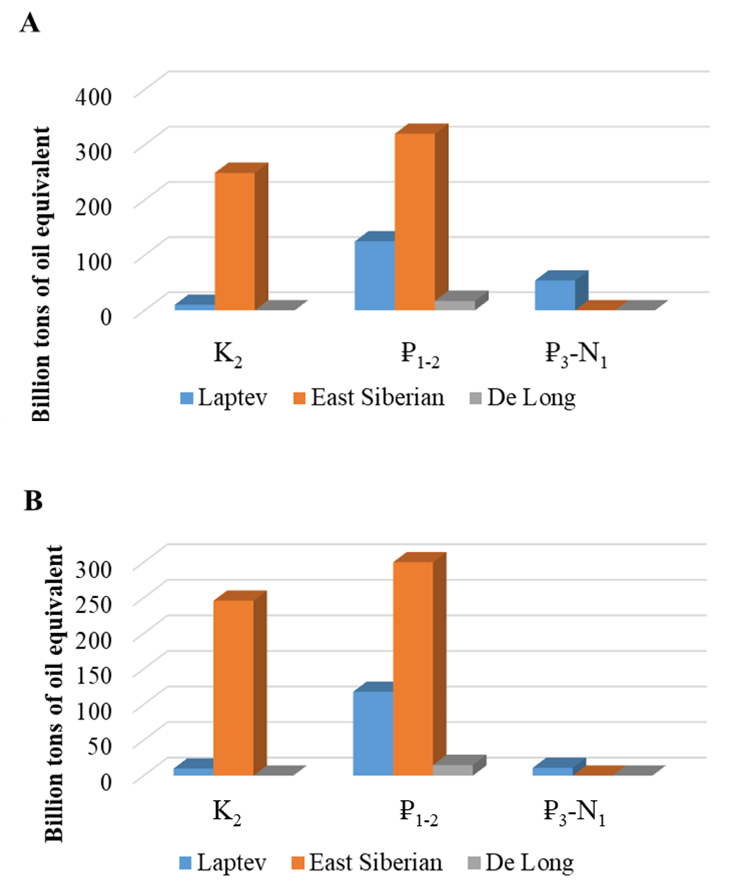
Fig. 8. Calculated volumes of generated (A) and expelled (B) hydrocarbons from the identified pods of active source rocks (Laptev, East Siberian, and De Long). Letters indicate the age of the source rock-bearing intervals: K2 (Late Cretaceous), ₽1-2 (Paleocene–Eocene), and ₽3–N1 (Oligocene–Early Miocene).
The regional paleogeographic reconstructions of the key evolutionary stages of the sedimentary cover, integrated with published geochemical data, have provided a forecast for the presence and distribution of potential source rocks within the East Arctic offshore areas. From the Paleocene to the early Miocene, the isolation from the global ocean – and the resulting pronounced water column stratification and widespread anoxic environments – created favorable conditions for the formation of high-quality source rocks across much of the Arctic Ocean.
However, specific thermal and tectonic regimes ensured the effective maturation and realization of hydrocarbon potential only within the Paleocene–Eocene section of the sedimentary record in the studied East Arctic region. Due to their low thermal maturity, Oligocene deposits do not serve as active source rocks across most of the East Arctic shelf. Consequently, the Paleocene–Eocene interval appears to be the primary petroleum play, defining the hydrocarbon exploration prospects of the region, followed in significance by the Upper Cretaceous complex.
The work was carried out within the framework of the state assignment of the Ministry of Science and Higher Education of the Russian Federation No. AAAA-A20-120092590017-4.
1. Backman J., Moran K. (2009). Expanding the Cenozoic paleoceanographic record in the Central Arctic Ocean: IODP Expedition 302 Synthesis. Central European Journal of Geosciences, 1(2), pp. 157–175. DOI: 10.2478/v10085-009-0015-6
2. Burnham A. (1989) A Simple kinetic model of petroleum formation and cracking. Geochimica and Cosmochimica Acta, 43. pp. 1–11.
3. Dixon J., Lane, L.S., Dietrich J.R., Mcneil D.H., Chen Z. (2019). Geological History of the Late Cretaceous to Cenozoic Beaufort-Mackenzie Basin, Arctic Canada. DOI: 10.1016/B978-0-444-63895-3.00017-6
4. Dore A., Lundin E., Gibbons A., Sømme T., Tørudbakken B. (2016). Transform margins of the Arctic: a synthesis and re-evaluation. Geological Society London Special Publications, pp. 431–487. DOI: org/10.1144/sp431.8
5. Grushevskaya O.V., Uvarova I.V. (2020). Analysis of oil and gas source rock formations on the shelf of the Laptev Sea. Bulletin of Perm University, 19(2), pp. 166–174. (In Russ.) DOI: 10.17072/psu.geol.19.2.166
6. Evdokimova N.K., Yashin D.S., Suprunenko O.I., Kim B.I. (2007). Oil and gas source rock formations in the sedimentary cover of the East Arctic shelf. Bulletin of St. Petersburg University. Ser. 7, 1, pp. 109–110. (In Russ.)
7. Houseknecht D., Craddock W., Lease R. (2016). Upper Cretaceous and Lower Jurassic.
8. Lavrenova E.A., Kerimov V.Yu., Gorbunov A.A. (2024). Geodynamic zoning and structural-formational complexes of the sedimentary cover of the East Arctic seas of Russia. Mining Journal, 10, pp. 31–40. DOI: 10.17580/gzh.2024.10.04
9. Masterson D., Holba, A. (2021). North Alaska Super Basin: Petroleum systems of the central Alaskan North Slope. United States AAPG Bulletin, 105, pp. 1233–1291. DOI: 10.1306/01282120057
10. Magoon L.B., Dow W.G. (1994). The Petroleum System-From Source to Trap. AAPG Memoir, 60, 655 p. https://doi.org/10.1306/M60585
11. Moran K., Backman J., Brinkhuis H., Clemens S., Cronin T., Dickens G., Eynaud F., Gattacceca J. Jakobsson M., Jordan R., Kaminski M., King J., Koc N., Krylov A., Martinez N., McInroy D., Moore T., Onodera J., Kristoffersen Y. (2006). The Cenozoic palaeoenvironment of the Arctic Ocean. Nature, 441, pp. 601–630. https://doi.org/10.1038/nature04800
12. Morrell G.R., Fortier M., Price P.R. and Polt R. (1995). Petroleum exploration in Northern Canada. A Guide to Oil and Gas Exploration and Potential. Northern Oil and Gas Directorate Indian and Northern Affairs Canada. https://www.aadnc-aandc.gc.ca/DAM/DAM-INTER-HQ/STAGING/texte-text/nog_pubs_penc_1324579829739_eng.pdf
13. O’Regan M., Moran K., Backman J., Jakobsson M., Sangiorgi F., Brinkhuis H. et al. (2008). Mid-Cenozoic tectonic and paleoenvironmental setting of the central Arctic Ocean. Paleoceanography, 23, pp. 1–15. https://doi.org/10.1029/2007PA001559
14. Palma J. Botterell, David W. Houseknecht, Paul G. Lillis (2021). Geochemical advances in Arctic Alaska oil typing – North Slope oil correlation and charge history. Marine and Petroleum Geology, 127, pp. 1–24. https://doi.org/10.1016/j.marpetgeo.2020.104878
15. Peters K. E., Magoon L. B., Bird K. J., Valin Z. C., and M. A. Kelle M. A. (2006). North Slope, Alaska: Source rock distribution, richness, thermal maturity, and petroleum charge. AAPG Bulletin, 90(2), pp. 261–292. https://doi.org/10.1306/09210505095
16. Polyakova I.D., Borukaev G.Ch., Sidorenko Sv.A. (2017). Potential oil and gas prospects of the East Siberian Sea. Geology of Oil and Gas, 1, pp. 3–10. (In Russ.)
17. Polyakova, I.D., Bogoyavlensky, I.V., Danilina, A.N. (2013). Characteristics of Arctic gas-and-oil resource strata, paleogeographic and geodynamic aspects of their formation. Arctic: ecology and economy, 1(9), pp. 46–59. (In Russ.)
18. Somme T.O., Dore A.G., Lundin E.R., Torudbakken B.O. (2018). Triassic paleogeography of the Arctic: Implications for sediment routing and basin fill. AAPG Bulletin, 102(12), pp. 2481–2517. https://doi.org/10.1306/05111817254
19. Stein R., Boucsein B., Meyer H. (2006). Anoxia and high primary production in the Paleogene central Arctic Ocean: First detailed records from the Lomonosov Ridge. Geophysical Research Letters, 33, pp. 1–6. DOI: 10.1029/2006GL026776
20. Stein R. (2007). Upper Cretaceous/lower Tertiary black shales near the North Pole: Organiccarbon origin and source-rock potential. Marine and Petroleum Geology, 24, pp. 67–73. DOI: 1016/j.marpetgeo.2006.10.002
21. Stoupakova A.V., Suslova A.A., Bolshakova M.A., Sautkin R.S., Sannikova I.A. (2017).Basin analysis for the search of large and unique fields in the Arctic region. Georesursy = Georesources, Special issue, pp. 19–35. DOI: http://doi.org/10.18599/grs.19.4
22. Strata in Shallow Cores on the Chukchi Shelf. Arctic Alaska. Professional Paper 1814–C. Studies by the U.S. Geological Survey in Alaska, 15, pp. 37. https://pubs.usgs.gov/pp/1814/c/pp1814C.pdf
Elena A. Lavrenova — Cand. Sci. (Geology and Mineralogy), Lecturer at the Department of Geology and Exploration of Hydrocarbon Deposits
23, Miklukho-Maklaya str., Moscow 117997
Lavrenova E.A. The Forecast and Assessment of Source Rocks Generation Potential in the Sedimentary Cover of the Eastern Arctic. Georesursy = Georesources. 2025;27(4):177-191. https://doi.org/10.18599/grs.2025.4.21
 Email this article (Login required)
Email the author (Login required)
Email this article (Login required)
Email the author (Login required) Address of the Editorial Office: Ametievskaya magistral st., 18, build. 2, ap. 3, Kazan, Republic of Tatarstan, 420087, Russian Federation
Contacts of the Editorial Office: Phone: +7 927 039-05-30, e-mail: mail@geors.ru
Founder: Daria A. Khristoforova
Publisher: Georesursy LLC







.png)

