Georesursy (Georesources) is a peer-reviewed scientific and technical journal published since 1999. It's aim is to provide scientific information platform for exchanging knowledge and professional experience for all concerned with development and conservation of the Earth's interior in academia, industry and government.
The Editorial Office of the Journal Georesursy (Georesources) in its activity seeks to promote scientific cooperation, to form the scientific information environment, prompt and reliable distribution of information about research carried out by scientists and industrial workers in the field of prospecting, exploration and development of the mineral resource base of hydrocarbons and solid minerals.
Georesursy (Georesources) is an open access journal.
Current issue
EDITOR-IN-CHIEF’S COLUMN
Letter from the editor-in-chief of the Journal "Georesursy"
RESEARCH ARTICLES
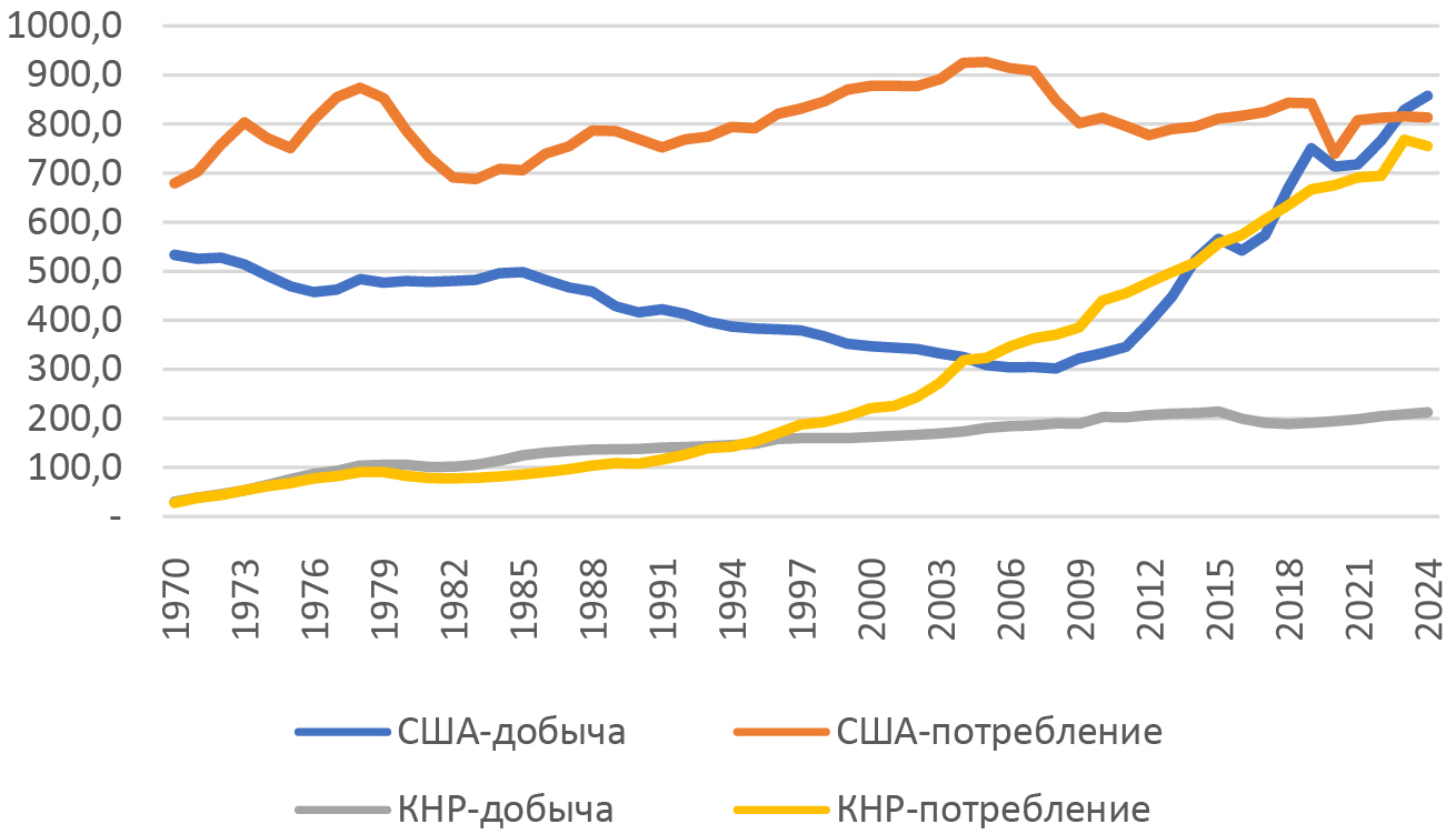
The article compares resource potential, geological characteristics, production dynamics and technological progress in the oil and gas sectors of China and the US, the countries that achieved significant progress in oil and gas production in the 21st century. The Chinese oil and gas sector operates under more challenging geological and geographic conditions, and, therefore, Chinese oil companies have to apply state-of-the-art technologies adapted to the local specifics, while the government has to provide substantial support and incentives. The authors study evolution of the institutional framework of the Chinese petroleum industry that was transformed through a series of reforms from a planned command-and-control to a planned market model. Reforms were aimed at enhancing efficiency and competitiveness of the oil and gas sector as well as at reducing import dependency on overseas energy resources while retaining the key role of the Chinese Communist party and state ownership over strategic assets; in general, they achieved expected results. The article assesses prospects of shale gas production in China that the Chinese authorities perceive as an important driver of gas production growth in the country.
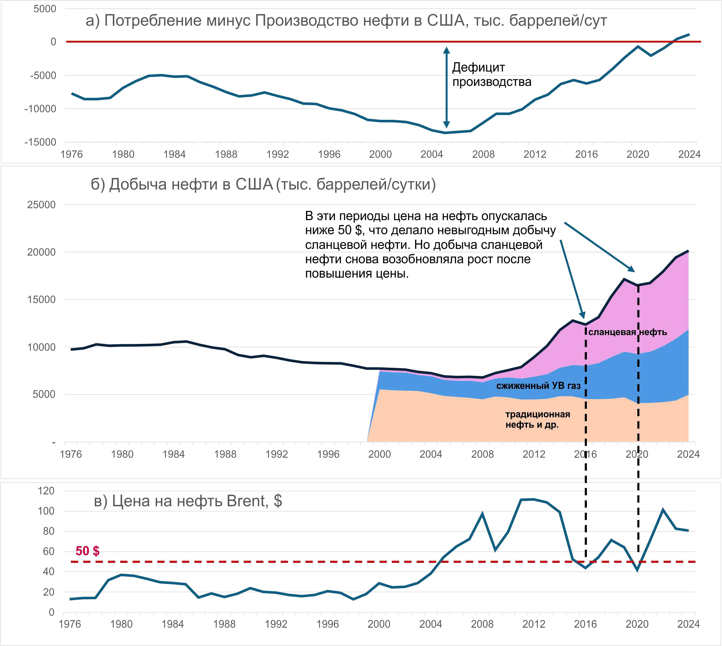
The article examines the dynamics of primary energy production in the period from 1970 to 2024. The significance of various types of fuels and energy in this time period is also being assessed. Despite the growing production of alternative energy sources such as wind, solar, geothermal and biofuels, which accounted for 3.6% of the total global fuel and energy mix in 2024, fossil fuels still remain predominant. In the same year, its share was 88.8%. In recent years, there has been a steady increase in the production of alternative energy sources. If current trends continue, their share may increase significantly by 2036, reaching 13%. All types of fossil fuels are also showing steady growth in production. However, the most significant of them is oil, which in 2024 accounted for 35.1% of the total global fuel and energy balance. The US experience over the past 20 years clearly demonstrates that a reduction in conventional oil production can be significantly offset by shale oil and liquefied petroleum gases.
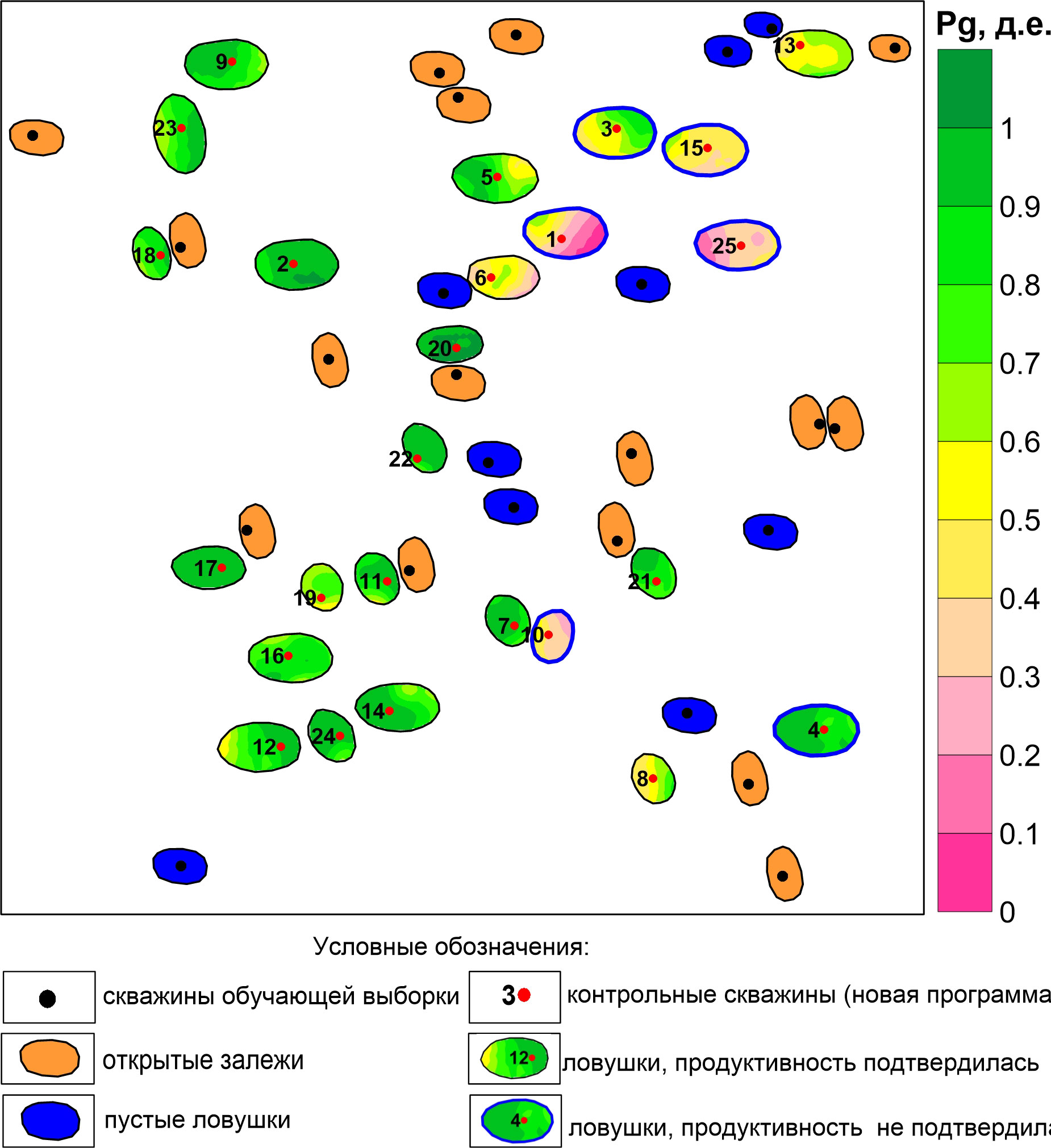
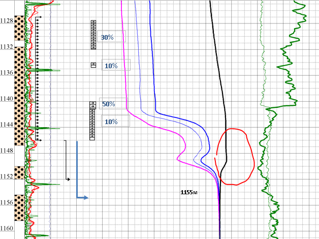
The problem of forecasting the results of geological exploration at various stages is very relevant in the development of licensed areas. According to the authors, it can be solved through the technology of probabilistic assessment of localized resources and reserves, taking into account the probabilities of the field existence. The purpose of the study is to increase the reliability of such estimates based on a geostatistical approach to interpreting data from modern methods of geological investigation. To achieve this goal, two scientific tasks were solved: the task of estimating the probability of the existence of a field (Pg) at the evaluation stage, and the task of estimating the probability of the existence of a field at the point of the exploration well (Pe) at the exploration stage. The article uses model data to show that the key components of Pg – the probabilities of the existence of a reservoir and a seal within the trap – can be estimated based on the results of their seismic prediction: final maps and maps of the standard deviation of the discrepancies. The probability of the existence of structural traps can be obtained from stochastic modeling of structural surfaces, and the probability of their filling – from basin modeling. The Pe components – the probability of a reservoir existence at the point of the exploration well and the probability of a reservoir top to be above the product-water contact also can be obtained from the results of seismic forecasting. The main advantage of the proposed approach is an objective quantitative assessment of the probability of the field’s existence, based on modern research technologies and the degree of study of objects. The main problem is the degree of reliability of the estimation of statistical parameters of the general population according to the sample data. Although the first results of its solution look encouraging, research in this direction needs to be continued.
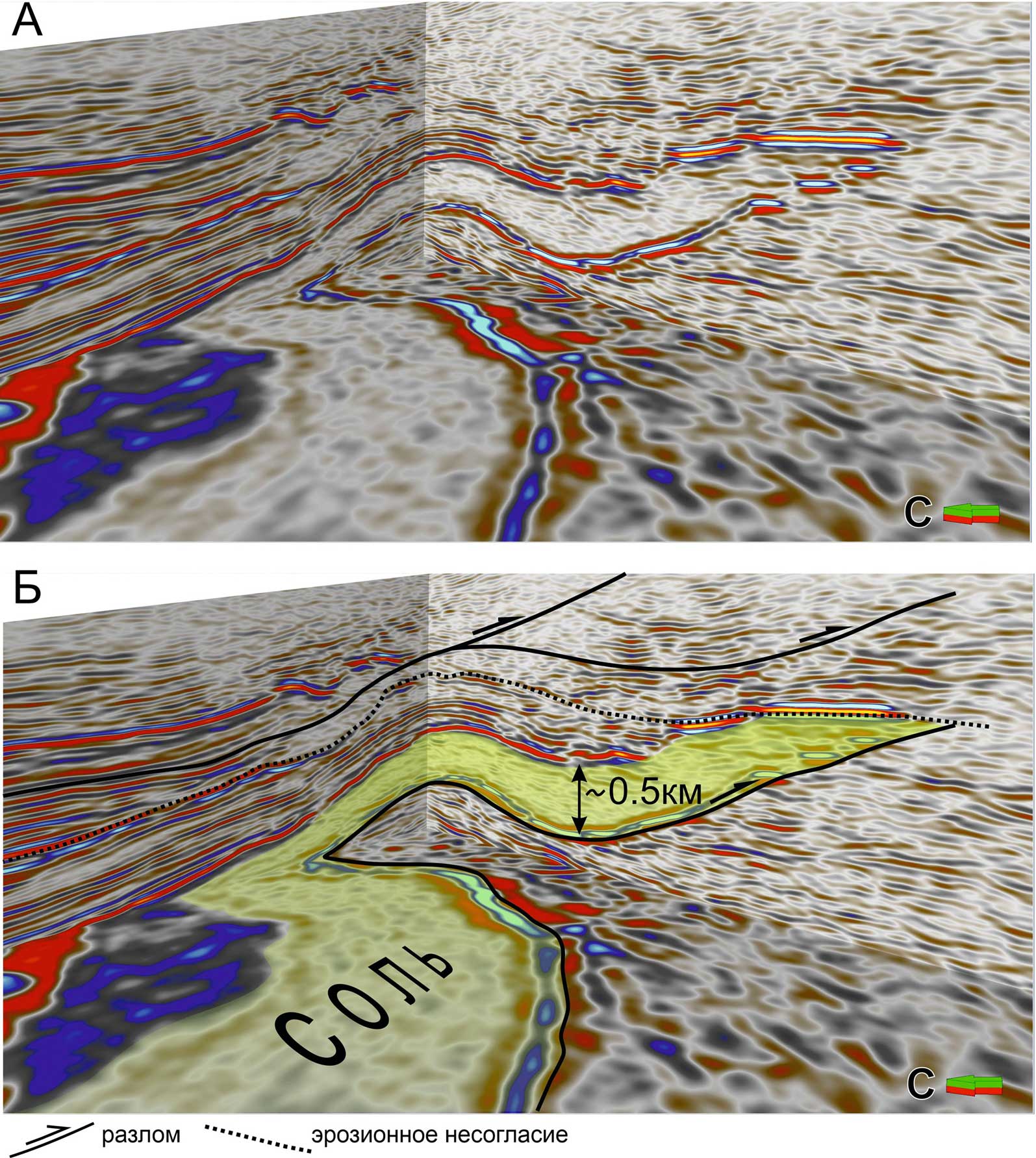
The structure of the Chernyshev Swell is one of the main mysteries of the structural geology of the Timan-Pechora Basin. This fold-thrust zone is characterized by a set of features, including the significant remoteness of the Ural orogen, a high degree of deformation of its constituent rocks, the divergence of thrusts on its flanks, lateral segmentation, and disproportionately widespread development of upper Ordovician-lower Silurian sediments on the surface. An interpretation of the structure of the Chernyshev Swell is proposed, the main element of which is the presence of longterm salt diapirs that were squeezed during collisional shortening. Compression led to the formation of large thrust overlaps due to the transformation of salt walls into mushroom-shaped diapirs and salt-detached thrust sheets. The largest salt-detached thrusts are found in the transition zone between the Chernyshev Swell and the Kosyu-Rogov Trough, where the horizontal overlap is 15 km or more. Various traps in the Upper Ordovician-Permian sediments are predicted under allochthonous salts. The proposed interpretation can be used as an a priori geological model for processing seismic data. This will provide additional geologically significant information that will reduce the uncertainty of geological structures and allow definition of new hydrocarbon leads.
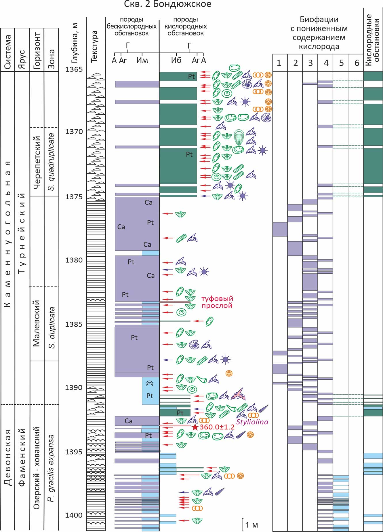
Organic-rich Devonian–Carboniferous deposits from the axial and marginal zones of the Kama–Kinel Trough System were investigated. Conodont data place the upper Famennian interval in the expansa Zone and the lower Tournaisian interval in the duplicata and quadruplicata Zones. Six biofacies were identified, described and illustrated, representing anoxic, dysoxic and relatively oxygenated settings. These biofacies differ in organic-matter content, the abundance and diversity of skeletal remains, the character of microbial buildups, and rock textures, including ichnotextures. The studied sections show frequent alternations of biofacies, from metre-scale to centimetre-scale intervals, with the finest alternation recorded on the trough slope. Three depositional scenarios are proposed, corresponding to three basin states: a fully anoxic basin affected by hydrogen sulphide, a stratified basin with separate oxic and anoxic water layers, and a basin with relatively high oxygen content throughout the water column.
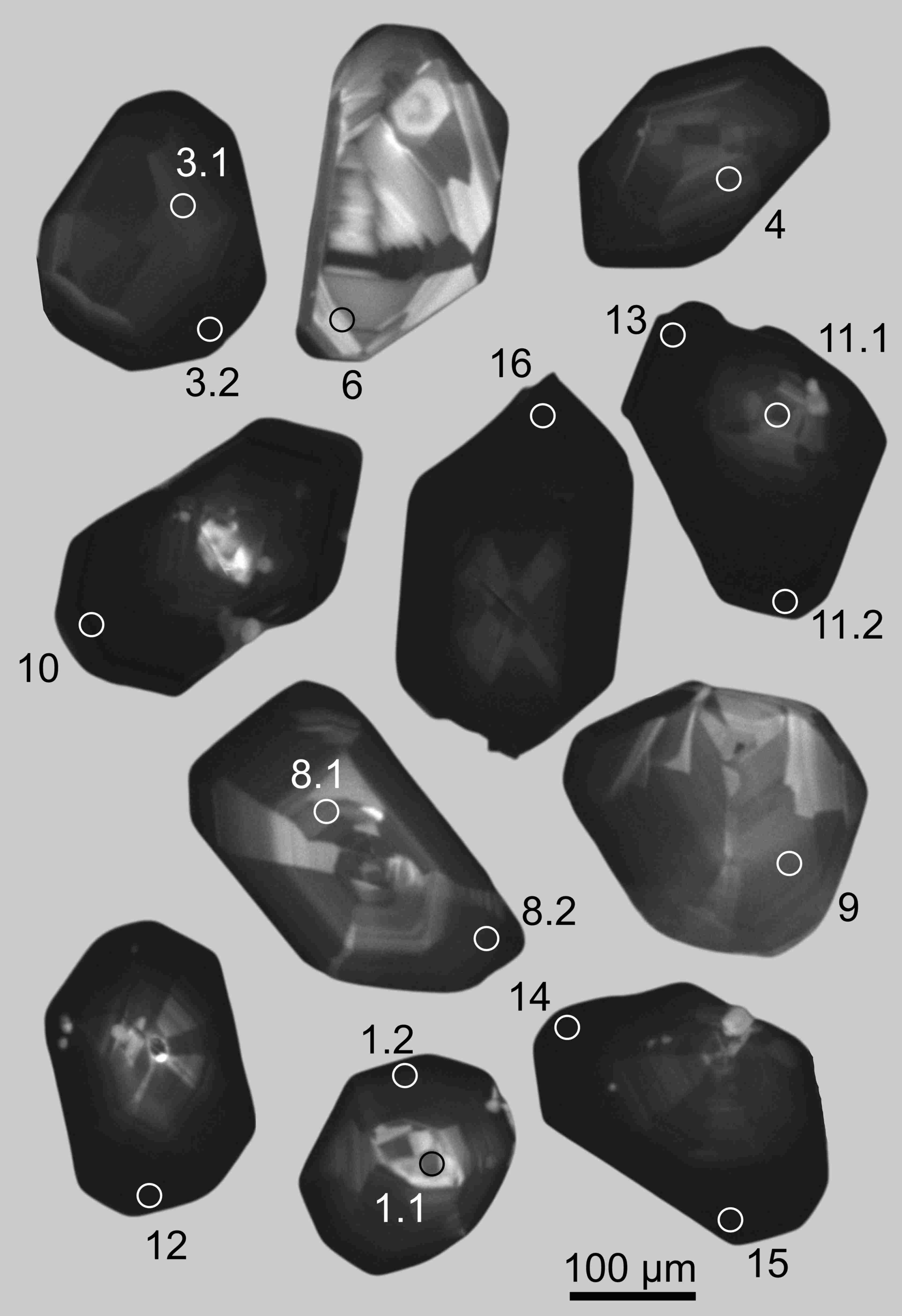
A positive Eu-anomaly, extremely rare for this mineral, has been found for zircon from the silicate marbles of the Khapchan terrane of the Anabar Shield and syenites of the Sukharninsky complex of granitoids of Chukotka. In the silicate marble sample, a positive Eu-anomaly was found for late generation of zircon with an increased content of non-formula elements and volatile components. The age of zircon at the upper intersection is 1954±17 Ma (granulite metamorphism), the lower intersection is 984±49 Ma (tectonothermal event). Zircon with a positive Eu-anomaly tends to the lower intersection of discordia, which indicates a connection with late exposure to fluids. Zircon from syenites is characterized by black high-uranium marginal zones with a positive Eu-anomaly and enrichment with trace elements. The entire zircon forms a cluster with a concordant age of about 105 Ma. It is likely that the occurrence of a positive Eu-anomaly in zircon from syenites occurred as a result of the evolution of a closed magmatic system, without the involvement of an outside fluid. Zircon from silicate marble appears to have recorded the evolution of fluid composition: 1) the early fluid was enriched in boron and was predominantly aqueous, probably mobilized from the primary sedimentary protolith of silicate marbles; 2) the subsequent one, presumably separated in time from granulite metamorphism, was enriched in halogens (fluorine and chlorine), which was reflected in the composition of the late zircon generations. The paper shows that the lower intersection of the discordia, based on individual zircon generations with special geochemical characteristics (the content and spectra of REE, the amplitude and sign of the Ce- and Eu-anomalies, the content of non-formula trace elements, Th/U ratio), is very likely related to a real geological event rather than an analytical artifact.
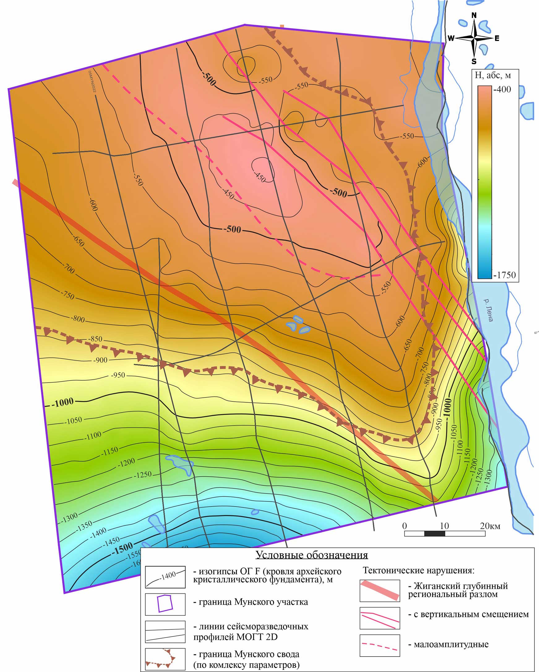
In 2024, the first stage of geological and geophysical research was completed within the framework of the Federal project “Geology: The legend revival” (2022–2024). The exploration areas are located in the zone of the junction of the three largest superorder elements: the Anabar anteclise, the Vilyuisk syneclise and the Priverkhoyansk trough. The purpose of this publication is to clarify the geological structure and oil and gas potential of this area.
Within the Anabar anteclise, on the Munsky arch there is a shortened type of section, there are no deposits of the coastal-continental Permo-Triassic formation with the Triassic and Permian Play, which are the most promising both in the Vilyuisk syneclise (confirmed by the presence of deposits on the Khapchagai shaft) and in the Predverkhoyansk marginal trough. However, there are Lower-Middle Cambrian, Vendian terrigenous and Vendian carbonate Play.
The presence of a large number of shallow wells in the Munskaya area made it possible to reliably map the erosive upper boundary of the Cambrian sediments in seismic sections and to clarify the position of the structural plan on the underlying horizons. The contours of the Munsky arch and the thickness of the sedimentary cover have been clarified. Structurally, the area under study is a monocline slope, plunging southward from the Munsky Arch into the Vilyui syneclise. During detailed analysis of the structure of deposits in the Munsky area, much attention was paid to the dynamic analysis of the seismic record in order to search for non-anticlinal prospects.
As a result, structural-stratigraphic and structural-lithological perspective objects in the Vendian deposits were mapped, which are clearly on the seismic sections.
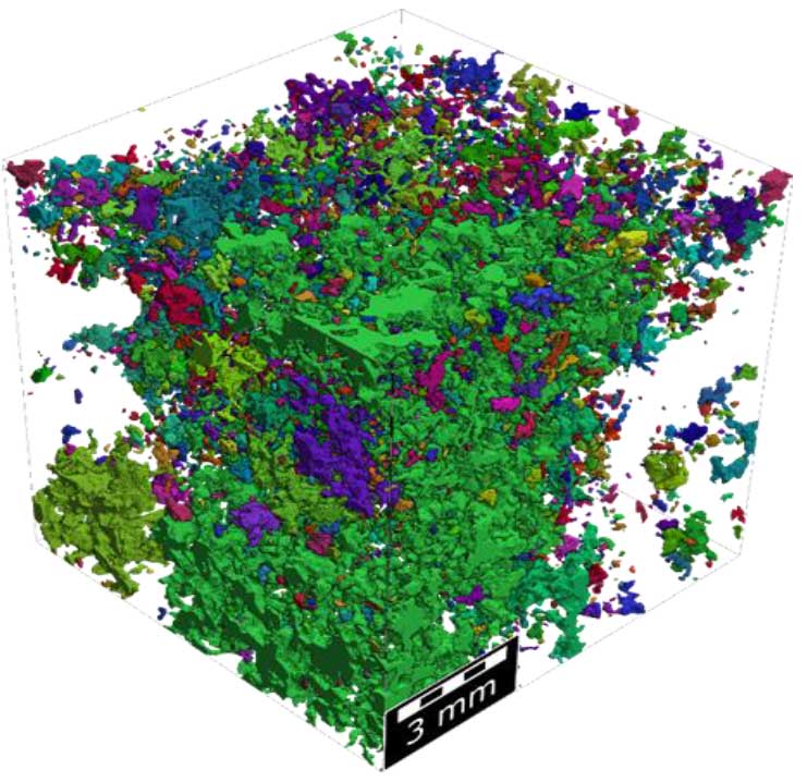
This paper systematizes the results achieved by BelNIPIneft specialists in the application of digital core technologies to the study of reservoir rocks in the Pripyat Trough. It presents information on the equipment used, research methods, and verification of the obtained results, as well as practical experience in the application of tomographic research results and digital core models to reservoir formations at oil fields in the Republic of Belarus. The paper presents the developed method for digital core analysis, a data sheet, and the results of scaling the number of digital core models to expand the representative range of reservoir properties. The paper briefly describes the results of using digital rock models in hydrodynamic modeling of reservoir development represented by terrigenous sediments and studies to determine the distribution of residual oil saturation after waterflooding in carbonate reservoirs at oil fields in the Republic of Belarus.
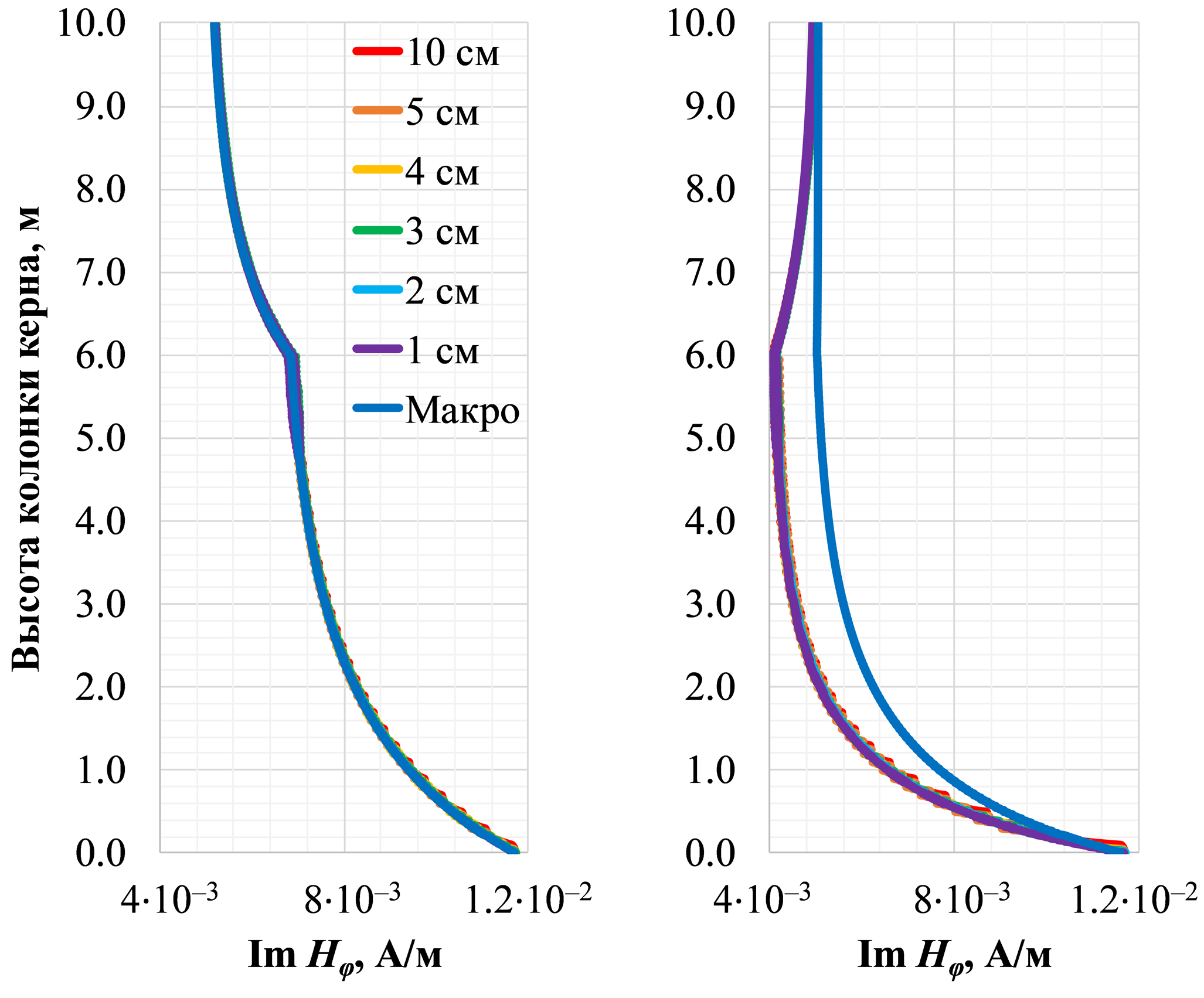
For the first time in the world practice, we have proposed transmitter-receiver systems with toroidal coils for evaluating the electrical resistivity of a cylindrical sample during core drilling. Two locations of the toroidal coils are considered: either in an insulating fiberglass pipe or in a highly conductive non-magnetic metal pipe, both inside a ferromagnetic steel outer core barrel. We have elaborated an algorithm for two-dimensional finite-difference modeling of electrical and magnetic signals from an external circular magnetic harmonic current equivalent to a toroidal coil, with regard to the magnetic permeability of the outer core barrel. Two-dimensional numerical modeling of the real (in-phase) and imaginary (quadrature) parts of the electric field vertical component and the magnetic field tangential component is conducted for typical terrigenous core resistivities. Subsequent to the numerical modeling results, the optimal lengths of the logging-while-coring systems, as well as the operating frequencies and measured signal types have been chosen when the coils are located either in the fiberglass or in non-magnetic metal pipe. Further, we come up with transforms of the measured signals into apparent resistivity values for vertically-variable core samples. Finally, we have worked out criteria for the consistency between the signals measured in thin-layered and equivalent electrically macroanisotropic cores while varying the resistivity contrast and interlayer thickness.
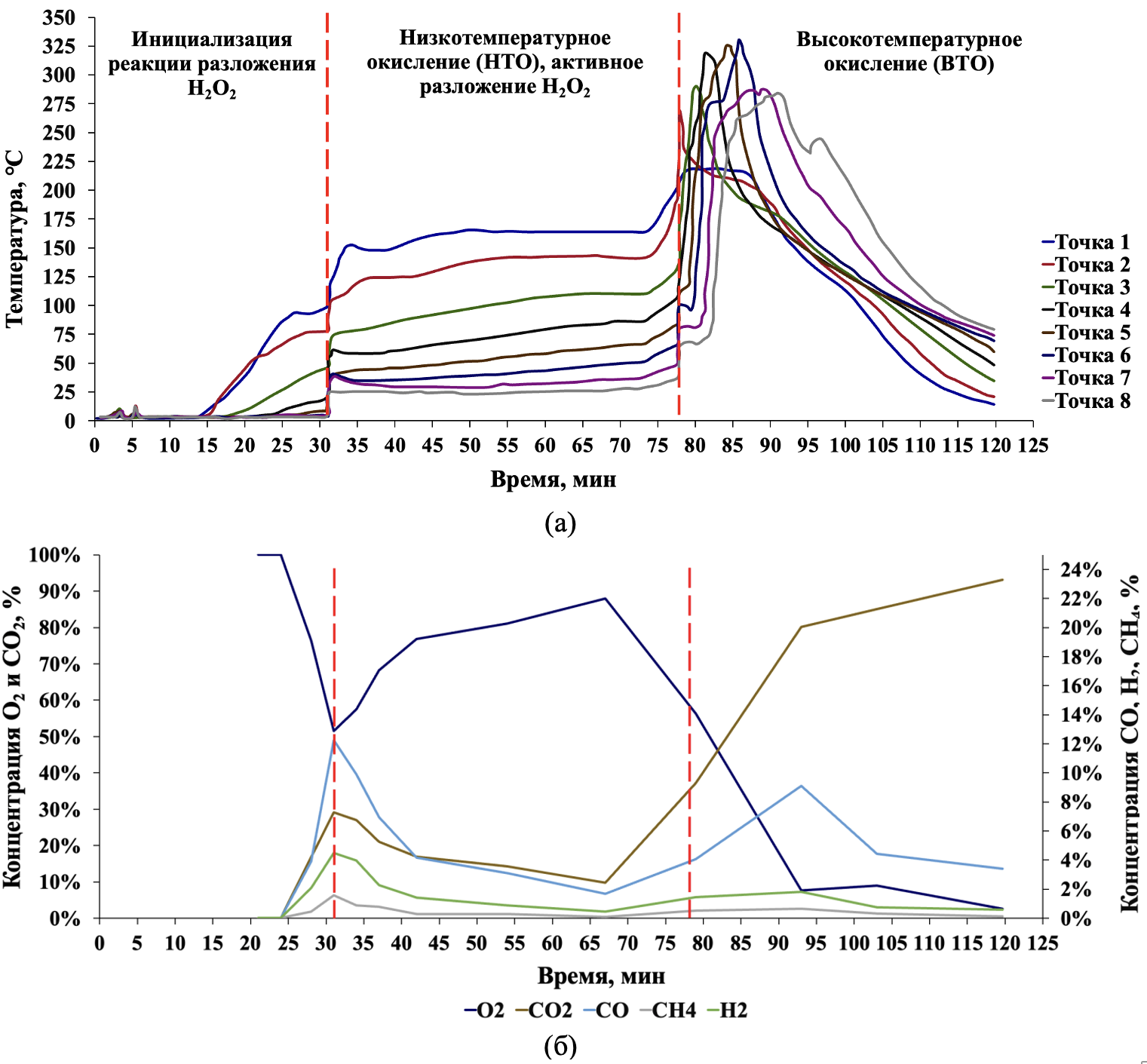
This study presents a comprehensive experimental and numerical investigation of a promising enhanced oil recovery (EOR) technology based on hydrogen peroxide (H2O2) injection and the initiation of in-situ combustion (ISC). The key advantage of the proposed technology is the ability to initiate high-temperature oil oxidation without surface air injection, as the required oxygen is generated directly within the reservoir through the decomposition of the injected H2O2.
The study included a comparative evaluation of the catalytic activity of iron oxide (Fe2O3) and manganese oxide (MnO2) nanoparticles, as well as an aqueous potassium permanganate (KMnO4) solution for initiating the peroxide decomposition reaction in the reservoir. It was found that under reservoir conditions, the aqueous KMnO4 solution undergoes reduction upon interaction with high-molecular-weight oil components, forming a solid MnO2 phase, thereby becoming immobilized in the pore space and preventing catalyst washout. As a result, the catalytically active layer forms predominantly in oil-saturated zones, localizing heat release during H2O2 decomposition and preventing non-target consumption of the reagent. In laboratory experiments, a maximum temperature of 336°C was achieved, and gas chromatography analysis confirmed the formation of components characteristic of complete oxidation processes, indicating successful ISC initiation. Numerical simulations performed using the CMG STARS software package confirmed the experimental findings, demonstrating that H2O2 decomposition initiates ISC through a sequence of processes: an exothermic peroxide decomposition reaction with significant oxygen release, followed by oil oxidation transitioning into a high-temperature regime with the formation of a stable combustion front. The model accurately reproduces the temperature profiles and gas composition dynamics, allowing the use of obtained kinetic parameters for predictive simulations and optimization of operational parameters.
The implementation of a stable oxidation front driven by oxygen generated from H2O2 decomposition without air injection has been demonstrated. The investigated method represents a promising solution for initiating and maintaining ISC, eliminating the need for complex and costly surface equipment for air or oxygen injection into the reservoir.
The development challenges of carbonate reservoirs in the Volga-Ural petroleum province are associated with their geological features (presence of fracturing, high formation water salinity, high oil viscosity, hydrophobic rock surface properties). While global practice employs well-established gas and physicochemical methods, Russia practically doesn’t apply conventional EOR techniques in carbonate reservoirs. The article emphasizes that the main methods of carbonate formation stimulation in the Volga-Ural petroleum province include: injection profile conformance technologies (small-scale EOR) as well as production well stimulation through acid treatments. A comparative analysis of literature is provided, reflecting the main types of implemented geological and technical measures. The authors describe in detail their developed individual elements of systemic technology adapted for carbonate reservoirs, optimized for each type of impact based on the industry’s achieved technical level – thereby demonstrating that all geological and technical measures for carbonate reservoirs have been refined and their effectiveness proven. The systematic approach to injection and production well treatments requires multiple expansions and replication, which should lead to profitable reserve recovery in carbonate reservoirs when applying best practices of geological and technical operations.

This study proposes an optimization-based approach to determine the actual fluid composition of gas condensate reservoirs when obtaining representative samples are impossible. The method incorporates the well tests hydrodynamic modeling, laboratory analyses of non-representative lean samples, and field data, including the gas-condensate ratio (GCR). The reservoir composition is assumed to be a linear combination of lean gas and its equilibrium condensate. The proportionality (mixing) parameter is obtained by minimizing the discrepancy between observed and simulated GCR values obtained using tNavigator. Two variants are considered: 1) a scalar parameter, corresponding to mixing of equilibrium gas and condensate; 2) a vector-valued mixing parameter, permitting per-component adjustment for improved accuracy. For the vector mixing parameter, a check is performed for compliance with the gamma distribution of the obtained heavy component fractions relative to their molecular weight. The approach is verified for a synthetic case with a known reservoir composition. For a detailed 34-component “lean”’ sample model, the scalar parameter approach accurately reproduces key PVT properties such as the dew point pressure and condensate dropout curve from constant-volume depletion tests. Reduced-component fluid models require the vector-valued mixing parameter to achieve comparable accuracy. To evaluate robustness against field uncertainties, Gaussian noise is introduced into the actual GCR data. Numerical experiments confirm that the method remains reliable if the error in noisy data does not exceed 10% relative to actual GCR.
This review examines the historical background and current state of enhanced oil recovery (EOR) using surfactant injection in depleted oil fields in Russia and around the world. Current trends and prospects for the development of this method are discussed. Historical accuracy is emphasized: not all surfactant flooding projects during the Soviet period were failures, as is commonly believed by modern researchers. Along with significant miscalculations, there were also some significant achievements. The review discusses the methodological foundations of surfactant screening, the scientific basis for selecting and optimizing surfactant compositions, and the role and mechanism of action of the main components. It also focuses on research related to the injection of surfactant compositions into oil reservoirs. Advances in the synthesis of surfactants used for EOR are described. Particular attention is given to the results of pilot tests and the effects achieved. It is shown that, given the current level of technological development in Russia and the current tax regime, the use of surfactant flooding is unprofitable. At the same time, the injection of surfactant rims and their combination with injection well slurries is successfully developing and is an effective tool for enhancing oil recovery in brownfield areas.
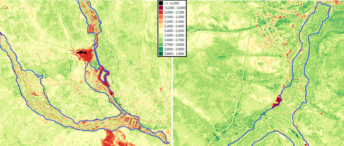
The article examines a methology for calculating the volume of territories with dredge tailings formed as a result of alluvial deposits mining in the Russian Far East, using remote sensing data. The study considers the application of digital elevation models SRTM, ASTER, ALOS, Copernicus, FABDEM and GEDTM. The modified algorithm of Voronoi diagram construction was used for segmentation of territories with dredge dumps, which allows to increase the accuracy of calculations in conditions of considerable length and heterogeneity of relief. A comparative analysis of the result of volume calculation was conducted for two sites – near the village of Briakan (Khabarovsk Krai) and Dzhalinda River (Amur Oblast) – with and without taking into account the height of vegetation cover was carried out.
The study identifies limitations of application of different digital elevation models and ways to improve the accuracy of estimation of the volume of territories with dredge tailings were proposed, which is important both for the assessment of environmental impact and for planning of potential recycling of anthropogenic formations.
Announcements
2026-05-14
Journal Georesursy SJR 2025 - Q2 (Geology)
The SCImago Journal Rank (SJR) data has been updated, with 2025 metrics reflecting current journal standings. Journal Georesursy SJR 2025 - Q2 (Geology).
| More Announcements... |

ISSN 1608-5078 (Online)