


Georesursy (Georesources) is a peer-reviewed scientific and technical journal published since 1999. It's aim is to provide scientific information platform for exchanging knowledge and professional experience for all concerned with development and conservation of the Earth's interior in academia, industry and government.
The Editorial Office of the Journal Georesursy (Georesources) in its activity seeks to promote scientific cooperation, to form the scientific information environment, prompt and reliable distribution of information about research carried out by scientists and industrial workers in the field of prospecting, exploration and development of the mineral resource base of hydrocarbons and solid minerals.
Georesursy (Georesources) is an open access journal.
Current issue
EDITOR-IN-CHIEF’S COLUMN

Letter from the editor-in-chief of the Journal "Georesursy"

The 4th Annual Conference “The Potential of the North of Western Siberia: Resources and Technologies” organized by NOVATEK PJSC, took place in Tyumen, Russia on June 16–17, 2026.

The article substantiates the joint development of oil and gas-condensate reservoirs in low-permeability strata and with near-critical state of reservoir fluids. The justification of similarity of geological structure of the Achimov strata in the conditions of deep cones of sedimentary fans, as well as its lithologic composition and reservoir properties are provided. The similarity of physicochemical properties of reservoir fluids under various thermobaric conditions, caused by the proximity of composition and near-critical state, is illustrated. A comparison between the scenario of independent development of the oil saturated Ach3 reservoir using a dedicated well pattern and the scenario of it joint development with the Ach5 1 gas-condensate reservoir using a combined horizontal well pattern with multistage hydraulic fracturing clearly demonstrates the advantages of joint development.
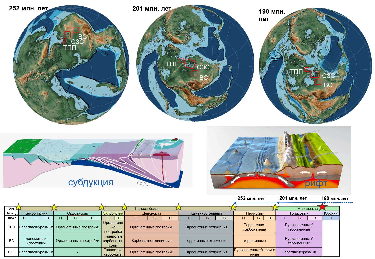
This paper presents the results of a regional study of the tectonic structure of the West Siberian Plate and its margins in the context of theoretical concepts regarding continental evolution. The main patterns governing the distribution of discovered pre-Jurassic basement deposits and the sedimentation peculiarities were studied, taking into account global plate tectonics. The study analyzes the impact of rifting - accompanied by active volcanism - on the structural features of the pre-Jurassic section. A paleoreconstruction of preJurassic deposits was conducted for specific areas in northern Western Siberia. A schematic model illustrating geodynamic and geochemical processes in northern Western Siberia from the formation of the pre-Jurassic complex to the present day was developed. Based on available data, sedimentation conditions during various stages of Paleozoic deposit formation were determined, and areas sharing similar geological processes were identified. Reflecting horizons were interpreted, and assumptions were made regarding the age of the associated deposits. Tectonic fault types were identified and linked to rifting and plate movements, resulting in a detailed tectonic model made for specific areas in northern Western Siberia. The published results substantiate the complex structural-stratigraphic composition and confirm the potential for oil and gas prospects of the pre-Jurassic basement.

The pre-Jurassic complex (PJC) of the Frolovskaya mega-depression in Western Siberia is a promising direction for expanding the resource base: 68 fields are currently on the state balance, holding geological reserves of approximately 965 million tonnes of oil equivalent. This paper summarizes experience in interpreting wide-azimuth 3D seismic data to study the structure and petroleum potential of the complex over an area characterized by 10 surveys (covering more than 2800 km²), 90 exploration wells, and over 500 production wells. It is shown that a reliable structural model of the PJC is achieved through full-azimuth anisotropic depth migration, which improves the focusing of dipping reflections and the suppression of multiples under conditions of erosional relief and a weathering crust. For areas of acid volcanic rocks development of Late Permian–Early Triassic age, a relationship has been established between lithological composition (tuffs, rhyolites, metarhyolites) and elastic properties: the most promising reservoirs are porous tuffs with reduced acoustic impedance, traceable from simultaneous seismic inversion data; reservoirs with a complex pore-space type are not reliably distinguished by elastic properties. Beyond the volcanic areas, a probabilistic forecast of the compositional makeup of the PJC’s near-top section is proposed, using Gaussian discriminant analysis applied to P-impedance and Vp/Vs maps, based on a core elasticproperty database (more than 360 samples, 10 petroclasses). The integration of seismic exploration, petrophysics, and probabilistic modeling reduces drilling geological risks and improves the efficiency of exploration operations.
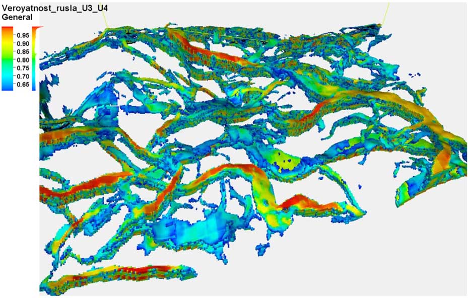
Delineation of paleochannel bodies from seismic data remains one of the practical tasks in predicting the lithofacies heterogeneity of terrigenous reservoirs. The paper presents a method for layer-by-layer delineation of paleochannel objects within a study interval bounded by two reflecting horizons using a neural network trained on synthetic examples, followed by construction of a volumetric probability model of paleochannel occurrence. The target interval is divided between the reference horizons into proportional slices; for each level, a composite is generated in which the R, G, and B color channels are filled with amplitudes from adjacent levels. Importantly, this approach better reflects the vertical variability of the seismic wavefield than frequencycolor composites obtained by spectral decomposition. A probability map of channel-type objects is then calculated. The training dataset is created by superimposing templates of modern river morphology prepared from open sources onto real seismic backgrounds, with variations in scale, contrast, brightness, inversion, and noise. At the application stage, global and local predictions are compared; test-time augmentation, several variants of local contrast enhancement, a sliding window with a Hann weighting function, and morphological post-processing are used. The result is a series of probability maps of channel bodies that can be used for preliminary tracking within the reservoir interval. The method is considered a support tool for seismic interpreters and sedimentologists rather than a standalone replacement for geological and geophysical analysis.

At a field in the north of West Siberia, an exploration well located on the basis of a geological model that relied on a bright-spot AVO anomaly encountered a watersaturated reservoir instead of the predicted gas saturation, as confirmed by formation testing with fluid sampling. The wrong prediction was caused by the mixing of gas- and watersaturated reservoirs in the AVO indicator domain (intercept– gradient) in the 2022 processing results, whereas synthetic seismogram modelling indicated a confident separation of saturation types: the gas reservoir corresponds to AVO class 4, and the water-saturated reservoir to class 3. To resolve this contradiction, four multi-vintage seismic surveys (vibroseis and dynamite sources) were reprocessed using the results of five wells and continuous interpretation-driven quality control. After each significant processing step, a seismic-to-well tie, an assessment of the AVO distribution at well locations, and a signal-to-noise estimate were performed, with the results integrated on a radar chart of control parameters. All controlled parameters improved: the dominant frequency increased from 30 to 38 Hz, the spectral bandwidth – from 45 to 52 Hz, the signal-to-noise ratio – from 12 to 13, the seismic-tosynthetic correlation coefficient – from 0.59 to 0.73, and the AVO correlation coefficient – from 0.7 to 0.8. As a result, the model-predicted separation of gas- and water-saturated reservoirs in AVO attributes was reproduced on the real data, and the key processing procedures ensuring conditioned results were identified.
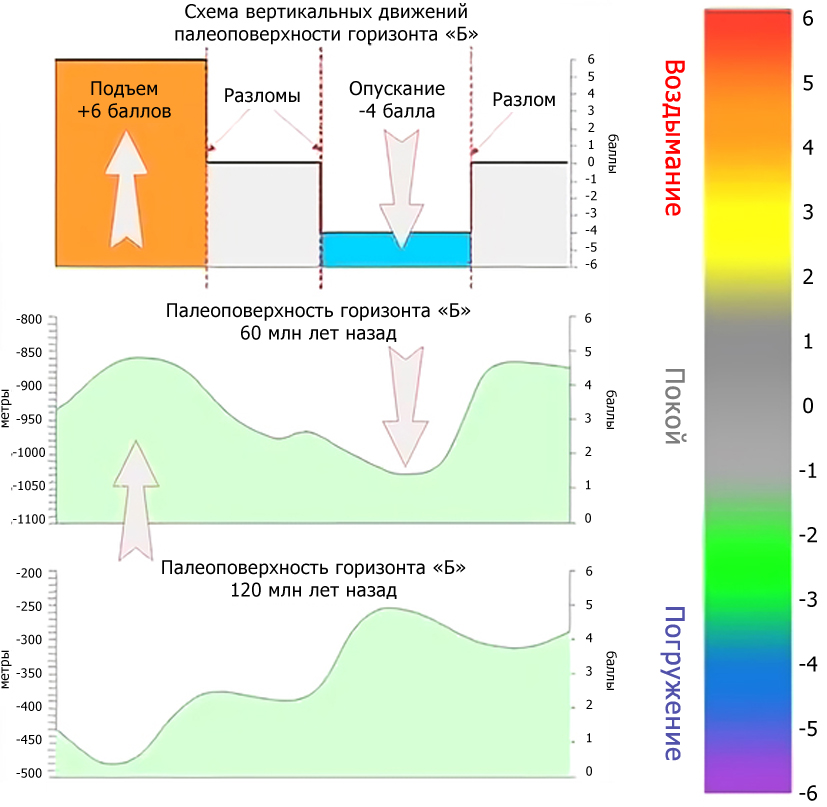
Dynamic paleotectonic analysis (DPA) was developed to study the direction (uplift/subsidence) and amplitude of movements affecting target horizons with potential for oil and gas traps. The primary objective of DPA is to identify zones of tectonic inversion – movements that trigger the formation of faults or zones of heightened mobility, which in turn facilitate the creation of hydrocarbon traps. Quantitatively assessing the dynamics of movement direction (uplift/subsidence) and amplitude allows for the identification of tectonic inversion zones within the sedimentary cover. In addition to traditional paleotectonic analysis, the DPA method enables a quantitative assessment of the geological evolution of the sedimentary cover. It helps to determine the geological epochs during which movement directions and amplitudes shifted and allows for the localization of tectonic inversion zones. Ultimately, this increases the probability of identifying areas likely to contain non-anticlinal hydrocarbon traps. In this work, the possibilities of supplementing qualitative analysis with a quantitative study algorithm are demonstrated using actual examples, allowing for the formalization of stages of paleotectonic evolution of the sedimentary cover and the numerical justification of the amplitudes and directions of tectonic movements.
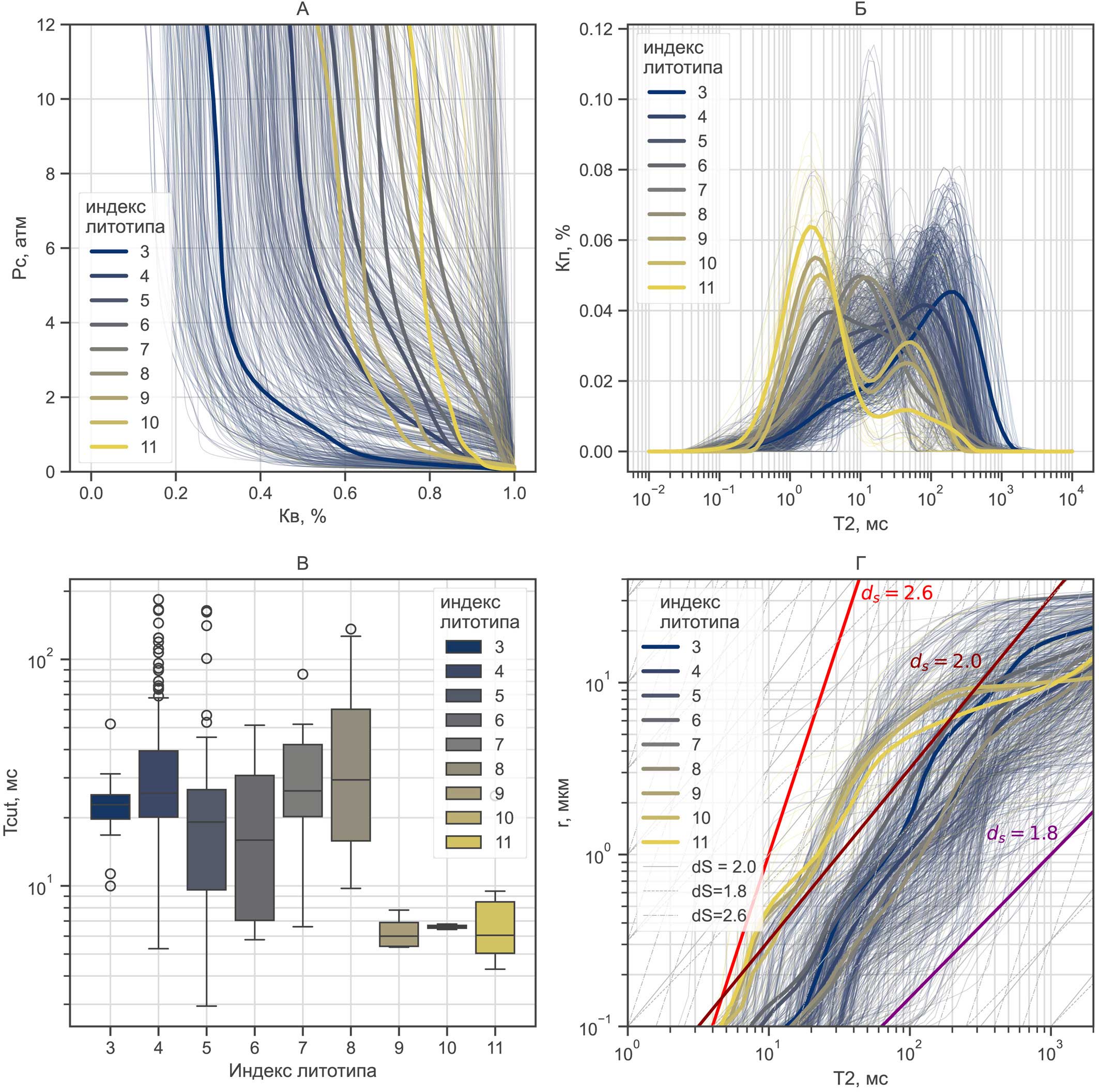
An approach to interpreting pore size distributions (derived from NMR relaxometry, mercury injection, and porous plate methods) based on a nonlinear transformation (quantile alignment, or quantile mapping) is proposed. Unlike conventional linear calibrations of the form r = cT2 (where r is the pore radius, c is the calibration coefficient, and T2 is the transverse NMR relaxation time), the proposed method accounts for the geometric heterogeneity of the pore space, enabling a closer match with experimental data when reconstructing capillary pressure curves from NMR results. Based on a dataset of 751 core samples, a correlation was established between the nonlinear transformation parameters and the lithological characteristics of the rocks. An interpretation of the r ~ T2 n relationship is proposed, accounting for the link between the pore surface fractal dimension ds and the exponent n. Based on a limited sample set, ranges of ds values for the considered rock types were estimated through pore-space image analysis using the box-counting method. It is shown that the apparent ds values derived from the r(T2 ) dependence are consistent with the ranges determined by the box‑counting method. Using a simple machine learning model (the k-nearest neighbors method) as an example, it is demonstrated that the quality of residual water saturation Swi recovery from NMR relaxometry data using the considered method corresponds to the quality of Swi recovery by the cut-off method when trained on the same dataset, with comparable accuracy of saturation estimation at other capillary pressure stages.

The paper presents a methodology for the rapid interpretation of X-ray fluorescence (XRF) data from drill cuttings, taking into account the lithogeochemical characteristics of the Achimov Formation deposits of the Urengoy oil and gas condensate field (Russia). Based on a comprehensive analysis of core and cuttings material, geochemical indicators were established that allow reservoirs and non-reservoirs, represented by clay-rich and dense carbonate-cemented intervals, to be distinguished. The chemical composition characteristics of genetically distinct clay types – upper, intraformational, and basal clays – were determined. These clay types exhibit similar geophysical characteristics according to the data from the full logging-while-drilling suite. The possibility of identifying clay types from XRF data of drill cuttings was demonstrated, enabling the rapid determination of the well position relative to the productive interval and informed adjustment of the well trajectory. Geochemical indicators were also established to distinguish natural dense carbonate-cemented intervals from carbonate contamination introduced into the cuttings from the drilling fluid in the form of marble chips. The results demonstrate the effectiveness of enhanced drill cuttings analysis in the Achimov Formation deposits of the Urengoy field for reducing non-productive drilling during horizontal well construction, both with a full and a minimal logging-whiledrilling suite.
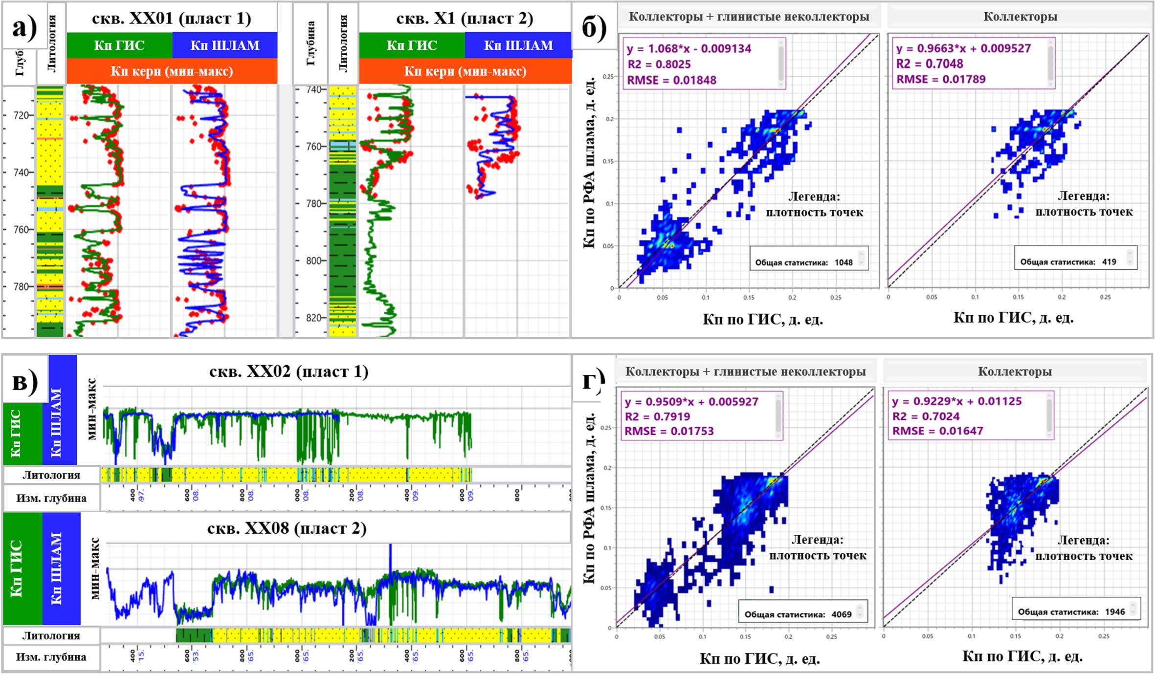
This paper is dedicated to expanding the application scope of X-ray fluorescence (XRF) analysis of drill cuttings in the Achimov deposits of the Urengoy oil and gas condensate field. The first part of the study addressed the lithogeochemical typing of the section using XRF data from drill cuttings. The second part presents a methodology for the real-time evaluation of formation reservoir properties during horizontal well drilling with a minimal logging-while-drilling (LWD) suite (gamma ray logging only, or its combination with resistivity measurements). The authors propose a simplified mathematical model for evaluating porosity based on the concentration of a single element indicator – zinc (Zn). The results of “blind testing” of the model on an exploratory well from an adjacent area confirm its reliability. The practical significance of implementing this porosity evaluation methodology for drilling horizontal wells with a minimal LWD suite is substantiated.

Structural correlation of reflection horizons remains one of the most labour-intensive operations in 3D seismic interpretation, particularly within the clinoform Neocomian sections of West Siberia, where target reflections show variable dynamics, pinch-outs and are complicated by faulting. Because horizon tracking is inherently sequential, we formulate it as a Markov decision process and solve it with reinforcement learning. Observing a local seismic context and the history of previously picked samples, an agent chooses, at each step, the vertical shift of the horizon on the adjacent trace; the reward function encodes geophysical criteria – waveform similarity to the reference reflection, phase consistency, lateral smoothness and fault tolerance. The method is implemented as a two-stage scheme: a policy first correlates the horizon over a grid of reference sections with a user-defined spacing, building a reliable network of anchors, and then densifies the result into a continuous surface across the whole volume. The agent is trained in a synthetic environment produced by forward full-wavefield modelling, with imitation pretraining on reference horizon trajectories; one or two intersecting reference sections suffice as input, and additional interpretation is introduced in complex zones. Tested on Achimov deposits of a field in Northern West Siberia, the approach agrees with manual correlation within 10 ms over conformable intervals. Limitations and directions for development are discussed.
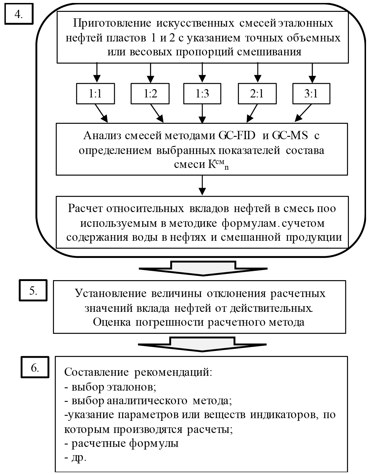
The technologies of joint exploitation of oil reservoirs in a single well grid are widely used in the development of multi-layer deposits. Simultaneous or dual completion operation of several oil-bearing facilities significantly reduces drilling and repair costs, and new facilities are put into development faster and at lower cost. However, these technologies require the mandatory introduction of separate accounting systems for the liquids taken from each reservoir. The first part of this publication provides a brief overview of modern methods for solving the problem of determining the relative flow rates of reservoirs during joint operation in a producing well. The advantages and disadvantages of engineering approaches to solving the problem, mathematical modeling methods, and technological methods for separate accounting of reservoir production are considered. The second part of the article describes an algorithm for conducting a chemical analytical study of well production in order to determine the contribution of productive formations to extraction during joint development. A number of methodological rules are proposed that make it possible to select indicators of the composition and properties of oils suitable for determining the contribution of individual strata to the mixed products. For the correct selection of reference oils of individual formations, it is recommended to take into account the geological block structure of the field and select wells from among those located as close as possible to wells with mixed products.
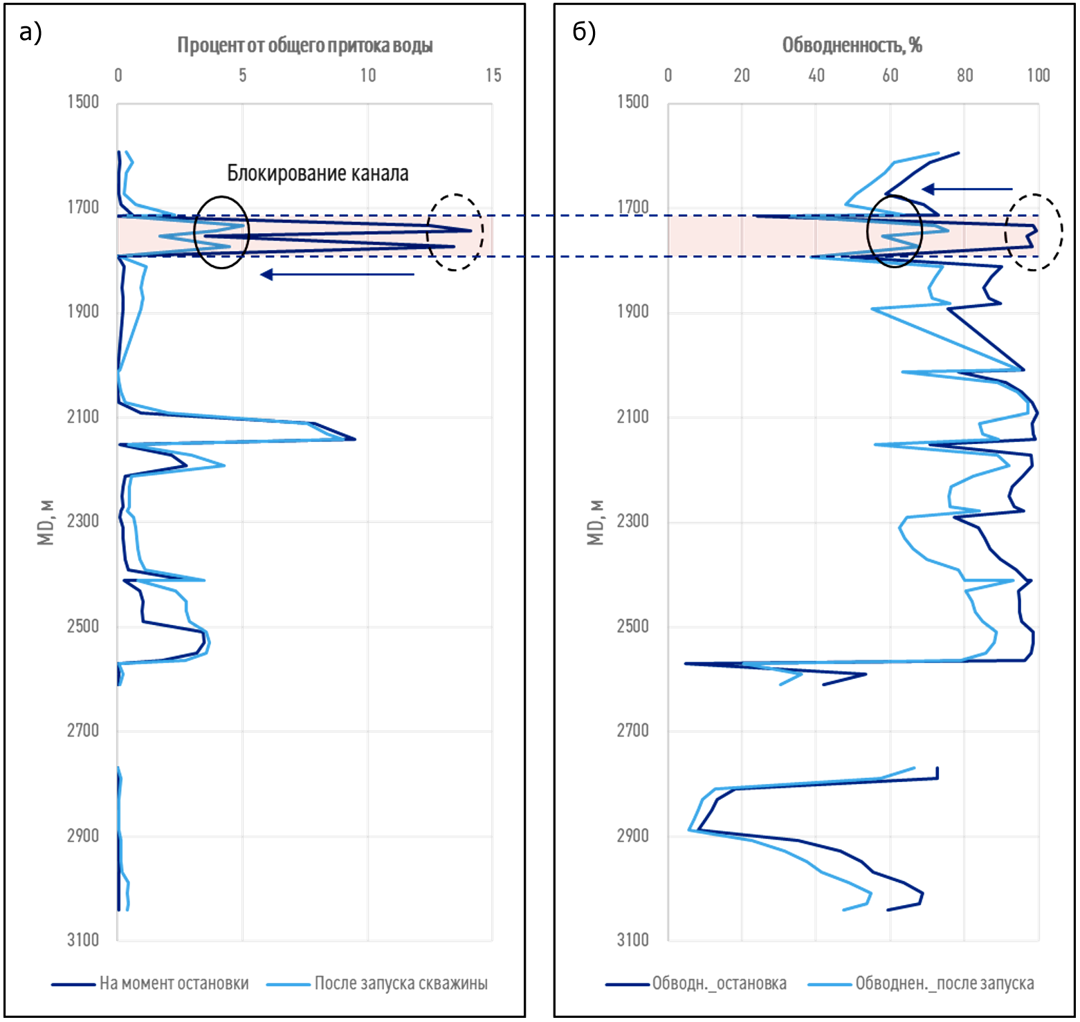
In the modern oil and gas industry, where efficiency and environmental safety play a key role, technologies aimed at optimizing production and minimizing environmental impact are particularly important. One such technology is a method for blocking water breakthrough with nitrogen to enhance oil recovery, based on AWACT (Anti-Water Coning Technology). This paper examines the basic principles, mechanisms, and methods for its effective application at oil field facilities. Laboratory filtration studies using a recombined oil sample confirmed that nitrogen injection can not only effectively combat water breakthrough but also contribute to increased oil production by changing the direction of water filtration and smoothing the inflow profile. The paper also developed a method for hydrodynamic modeling of AWACT technology, which was adjusted to the laboratory test results, allowing the optimal injection volume for horizontal wells to be determined: 300,000 m³ of nitrogen. This volume is sufficient to achieve significant results without excessive economic costs.
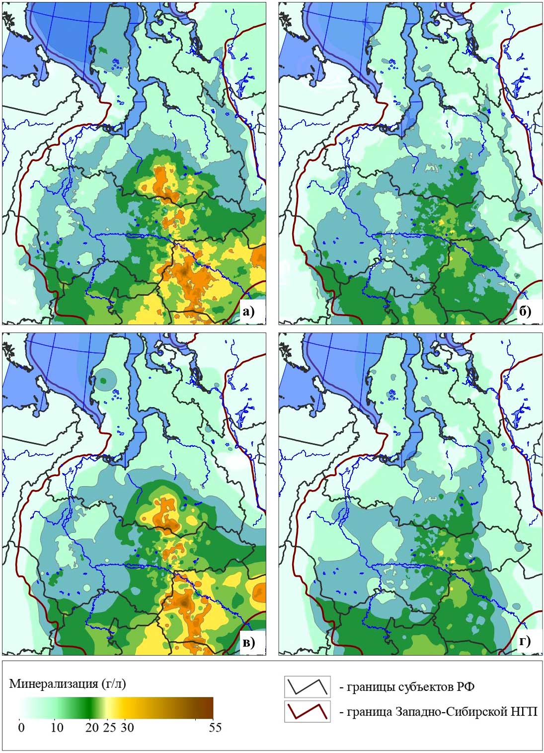
Contour maps or grid models are a common tool used to visualize and analyze groundwater hydrogeochemical parameter fields. Mapping results depend largely on the gridding methods and the density of actual data, which, particularly in the West Siberian megabasin, is relatively low and uneven across the area. Improving the quality of mapping in areas poorly studied by direct sampling is typically achieved through the use of indirect information on the spatial distribution of the parameter being modeled.
Assuming that the structural forms of horizons, particularly the thickness of complexes, locally control the configuration of certain hydrogeochemical parameter fields, detailed regional maps of the thicknesses of complexes were used as indirect information. Using the variational grid mapping method, groundwater mineralization maps were constructed for Jurassic and Neocomian sediments across Western Siberia. The relationship between mineralization and the thickness of complexes was specified as a condition of collinearity between the gradient vectors of these fields.
It is shown that this approach helps to avoid the appearance of artifacts on maps that are typical for standard smoothing methods and that complicate the meaningful analysis of the construction results, provides a higher level of detail in the results of mapping the spatial patterns of changes in hydrogeochemical indicators, and the degree of their consistency with the geological conditions of the deposits.
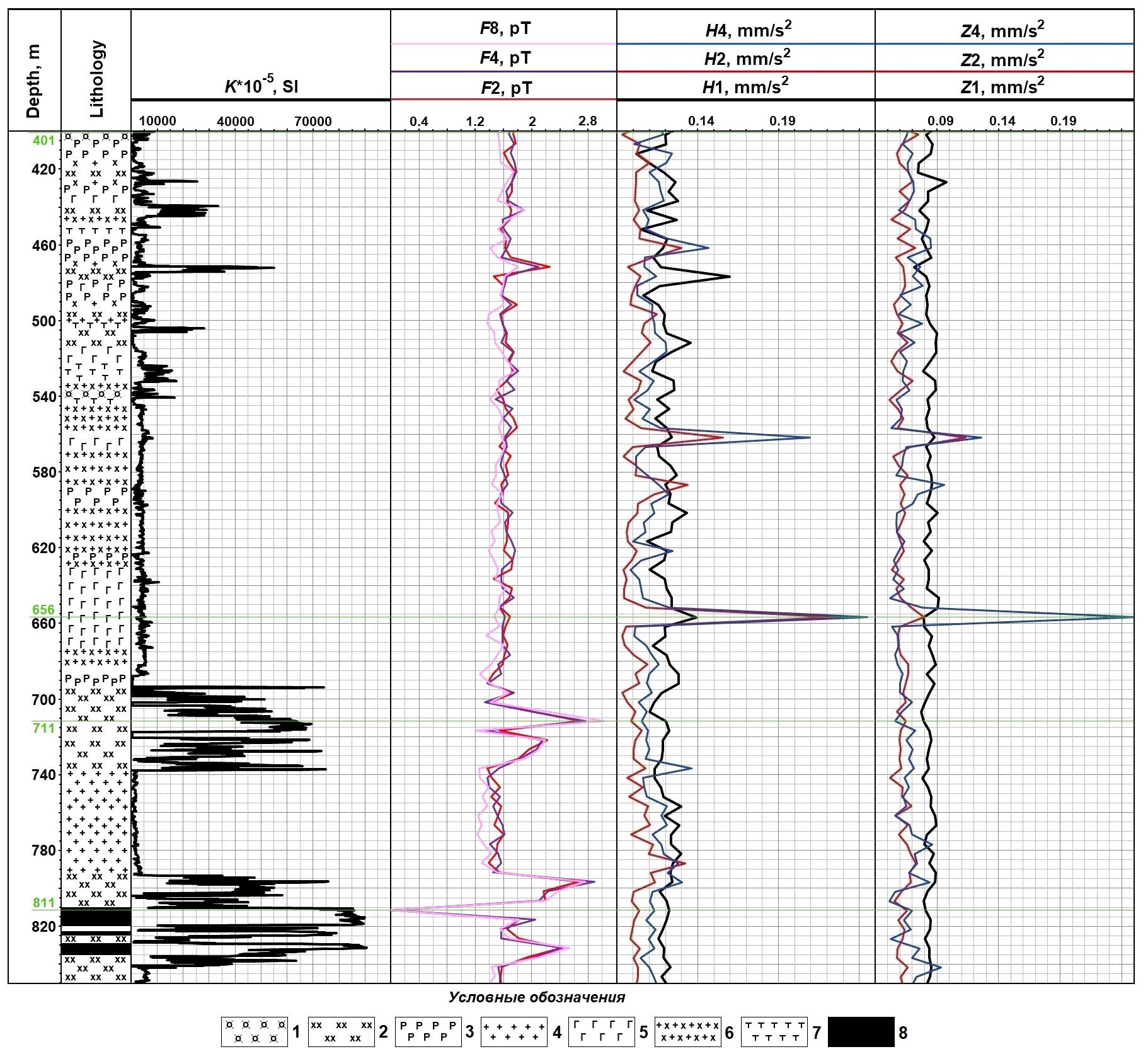
This paper presents the capabilities of a method for assessing the geodynamic conditions of a study area and predicting complications during well drilling and operation by identifying zones of increased stress and faulting in rock mass, as well as hidden geodynamic activity along the borehole. The method is based on an analysis of the spatial and temporal distribution of the amplitude-frequency characteristics of geoacoustic and electromagnetic signals generated by microvibrations of the geoenvironment in the borehole and borehole vicinity. The research utilizes the SHEST-4202 hardware and software system, developed at the Institute of Geophysics, Ural Branch of the Russian Academy of Sciences, designed for synchronous measurements of electromagnetic radiation (EMR) and geoacoustic emission (GAE) signals. The article presents the results of GAE and EMR parameter measurements conducted using the developed method in one borehole at an iron ore deposit in the Southern Urals. During interpretation of the obtained data, the borehole section was divided into two sections based on geodynamic activity. The upper part of the borehole section, in the depth range of 400–660 m, is geodynamically active, characterized by the presence of GAE anomalies of varying intensity, which indicate fracturing processes associated with contact zones of rocks with different strength properties. In the lower part of the borehole section, where GAE anomalies are absent on the well log, short-term monitoring revealed latent geodynamic activity at two depths, manifested by anomalous pulses of GAE parameters, predominantly in a subhorizontal direction. The presented method of borehole geophysical logging for studying the current geodynamic environment at solid mineral deposits allows for the acquisition of additional information for assessing changes in the stress-strain state of rock masses in the borehole vicinity and for predicting potential borehole wall collapses, cavern formations, and stuck underground equipment.
Announcements
2026-05-14
Journal Georesursy SJR 2025 - Q2 (Geology)
The SCImago Journal Rank (SJR) data has been updated, with 2025 metrics reflecting current journal standings. Journal Georesursy SJR 2025 - Q2 (Geology).
| More Announcements... |

ISSN 1608-5078 (Online)







.png)
