EDITOR-IN-CHIEF’S COLUMN

Letter from the editor-in-chief of the Journal "Georesursy"

OIL AND GAS CONTENT OF THE NORTH OF WESTERN SIBERIA

The article considers the results of development of hardto- recover reserves of gas condensate deposits in low-permeability Achimov and Jurassic formations with significant abnormally high reservoir pressure. The main geological, technological and economic factors complicating the development of these reserves are identified. Typical examples of the geological structure, filtration and capacity properties of Achimov and Jurassic formations that determine low well productivity are given. The evolution of the complexity of production well designs is shown. The influence of economic factors on the profitability of development and on the gas and condensate recovery factors of such deposits are analyzed.
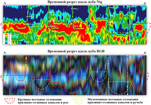
The main objective of this paper is to increase the efficiency of planning horizontal wells and refine the geological model of formations of coastal origin. Based on a comprehensive analysis of geological and geophysical information and a description of the core, a facies and a 3D geological models of TP16 formations of coastal origin were constructed. These formations are characterized by strong lateral variability and low net to gross. In the course of this research, data from seismic inversion, geophysical studies of wells and production logging were used. Updated seismic correlation and an interval analysis of seismic cubes, together with the data from well test results, made it possible to reliably determine the stratigraphy and chronology of accumulation of the studied formations. As a result of the performed research, seismic attributes describing the geological structure of the deposits, as well as the distribution of productive volumes and reservoir properties were obtained for each formation. Also, the boundaries of tidal-fluvial channels and floodplain areas were identified based on seismic attributes. Taking into account the acquired data, the facies and 3D geological models were updated and the drilling of exploitation wells was planned. The accuracy of the new geological model was confirmed by drilling 8 horizontal wells with an average effective penetration of the reservoir of 1640 meters (82%) and an average permeability coefficient of 108 mD.

The latest major technological change in seismic surveys at the sites of the NOVATEK Group of Companies is the use of high-performance sleep-sweep vibroseismic exploration technology.
The total volume of work performed in the NOVATEK Group of Companies using the sleep-sweep technology has currently exceeded 20 000 square kilometers.
As part of the assessment of the efficiency and prospects of the sleep-sweep, the article analyzes the optimization possibilities, as well as the risks and difficulties in implementing the technology, analyzes the performance of the sleep-sweep in the conditions of the Arctic region, and presents a methodology for predicting daily productivity, applicable for designing and assessing the technical and economic indicators of research.

The article outlines the prerequisites and results of using a specialized technology for processing vibrograms obtained during high-performance vibroseismic studies using the “slip-sweep” technology. The goal is to reveal the potential and advantages of multispectral adaptive data processing, mainly associated with improving the quality and information content of the results obtained. The prerequisites for the introduction of technology are the existence of an objective demand for high-performance seismic exploration methods and the physical feasibility, in modern conditions, of recording and processing data from the level of initial vibrograms. The work describes the advantages and disadvantages of the vibroseismic method and its high-performance modifications, provides a brief retrospective analysis of the topic of processing vibrograms before correlation, substantiates specific methodological approaches to reducing the technological noise of vibroseismic “slip-sweep” surveys, demonstrates specific examples of improving data quality (both at the level of correlograms, and at the level of total sections) with different numbers of groups of vibroseismic sources. The main conclusion is that processing vibrograms using the “slip-sweep” method provides an increase in quality comparable to at least a one and a half to twofold increase in the shooting magnification.

Using an integrated approach, 3D geological and hydrodynamic models were built using the results of facies analysis. A sedimentological description of the core was carried out with the interpretation of facies, the formation of which occurred in relatively deep-water sedimentation conditions of the Achimov strata and 7 facies were identified. Based on the results of the facies interpretation of the core, petrofacial modeling were performed according to the concept of pore space connectivity, connectivity coefficients (Sf) were selected and the dependence of the permeability determination for each facies was clarified.
In addition to determining facies by core, using the interpretation of lithology by logging, facies zones (A, B, C), associations of facies by area, seismic attributes (dynamic analysis), it was possible to perform a facies interpretation of logging curves (electrophations) and build facies maps for each cyclite within a large clinocyclite (formation). The geological model was built taking into account the internal structure of the formation and facies analysis, which made it possible to differentiate the formation into separate intervals with their dependences of filtration and capacitance properties.
This approach provided a better match of the model to the real geological structure and laid the predictive basis for subsequent drilling purposes.

A sequence-stratigraphic model of the Tanopchinskaya Suite of coastal continental genesis was constructed in order to establish the distribution patterns of reservoir properties, clarify the geometry of sand bodies, and identify the main hydrocarbon concentration zones within the studied sediments. The system approach to well correlation was substantiated, which formed the basis for creating a model of Cretaceous sediments with high predictive ability. Regional peculiarities of the structure of the Tanopchinskaya Suite of a large field in the Yamalo-Nenets Autonomous District of the Russian Federation were analysed; core and GIS data from 64 exploration wells and 224 production wells in TP1–TP26 formations were analysed; an algorithm for building a sequence-stratigraphic model that takes into account sedimentation peculiarities was formulated; peculiarities of sand bodies formation were revealed for the whole Cretaceous section. As a result of the analysis, all wells in the Tanopchinskaya Suite interval (TP1–TP26 formations) were correlated with the definition of facies environment and the main surfaces of sedimentation regime change (flooding surfaces, erosion incisions, transgressive surfaces). Taking into account the correlation of formations for the entire well stock, a geostatistical section was constructed and sequence-stratigraphic subdivisions characterising the Tanopchinskaya Suite formations were identified. The 1D sequence-stratigraphic model of wells was analysed for the main hydrocarbon accumulation zones, taking into account open deposits, and the regularities of their location in the section were formulated.

Based on the complex geological and geophysical information and results of laboratory core studies, the detailed structure of sand sediments of the underwater part of the delta system has been studied. This has allowed to explain the distribution of hydrocarbons in the deposits due to morphological features of sedimentological objects.
The work used the results of spectral decomposition of seismic data, interpretation of which allows to reconstruct with high detail morphology and structure of studied sediments. Sedimentological analysis of core was performed. The conclusions were compared with actual data of geological and geophysical well studies. The work identified two classes of sandstones with different filtration characteristics, which, taking into account seismic facies analysis, formed the basis for a conceptual geological model of the progradation of the sea delta coast with a predominance of wave processes.
The presented conceptual model explains the distribution of sand material, its filtration characteristics, takes into account the physical processes of formation of the sediment profiles and allows to more accurately predict the distribution of the productive part of the formation, which helps to increase the success of drilling horizontal wells.
The presented conceptual model explains the distribution of sandy material, its filtration characteristics, takes into account the physical processes of formation of the sediment profile of the sea coast and makes it possible to more accurately predict the distribution of the productive part of the formation, which helps to increase the success of drilling horizontal wells.

Based on an actual seismic geological model, a structural-tectonic zoning of the Paleozoic complex of Western Taimyr was carried out, including the territory of the South Taimyr monocline, where Paleozoic deposits are hidden under the Mesozoic sedimentary cover. Zoning was carried out for tectonic elements of different orders: regional, supra-order, structures of the 1st, 2nd, 3rd orders, local uplifts. When compiling a structural-tectonic scheme, an analysis of previous tectonic schemes by various authors and currently available materials was performed. In addition, much attention is paid to the main faults of Western Taimyr.
All available geological and geophysical data reflecting the tectonic structure of the study area was used, including structural maps of the top of the Paleozoic complex and horizons reflecting it’s internal structure, 2D CDP seismic sections, maps of potential fields (magnetic and gravity), maps of dips and azimuths of reflecting horizons, thickness maps, published and archive papers on this topic, including tectonic and geological maps.
As a result, an updated structural-tectonic diagram of the Paleozoic deposits of Western Taimyr was compiled, characterized by a high degree of detail, the fault model of the region was generalized and significantly refined, all tectonic elements and structures were assigned their own names, taking into account the results of previous studies, positive structures of the 1st order, which represent potential zones of oil and gas accumulation in the Paleozoic complex.

The paper is devoted to the problem of determining the composition of reservoir gas for gas condensate fields. A methodology for planning gas condensate tests (GCT) is proposed, which allows to assess the possibility of obtaining conditioned samples of reservoir fluid. For the case when it is impossible to take conditioned samples, an approach for their interpretation is developed.
At the first step it is proposed to numerically create a set of compositions by adding to the gas of the laboratory “depleted” composition a certain amount of condensate equilibrated to it. The resulting compositions have different condensation onset pressures above the laboratory pressure. Subsequently, for each of the obtained compositions hydrodynamic (HD) modeling should be carried out and the composition for which the obtained values of condensate and gas flow rates and gas oil ratio (GOR) are close to the GCT data should be selected.
The analysis of numerical experiments on synthetic flow rate data for a typical well shows a significant dependence of GOR on the component composition and low sensitivity to changes in the main parameters of the HD model. When adjusting the HD model according to the actual data, it is proposed to first select from the set of reconstructed compositions the one for which the model GOR values will be closest to the actual data. The next step, when the selected composition is fixed, is the selection of other parameters of the HD model based on the data of gas and condensate flow rates. This methodology was demonstrated to determine the component composition and main reservoir parameters from GOR data for one real well.

The purpose of this work is to improve the predictive ability of the geological model of coastal formations when assessing hydrocarbon reserves and laying production wells. The article presents the results of work on the analysis of the geometry of sand bodies of the formations of the TP group of the Tanopchinskaya suite. To determine the morphology of sandstones, the authors used an integrated approach that takes into account: the results of sedimentological core studies, well logging data, 3D seismic materials. The authors studied in detail the conditions for the formation of these rocks on the basis of actual material (core), and presented photographs with characteristic structural and textural features of the rocks, which make it possible to establish the conditions for their formation. Spectral decomposition sections were analyzed in detail in the studied interval at several license areas of NOVATEK.
The reasons for changes in the geometry of sand bodies from the perspective of sequence stratigraphy have been established and explained. In addition, an idea has been formed about the vertical evolution of the coastal zone under conditions of sea transgression. The filtration and reservoir properties of rocks were also analyzed based on measurements of porosity and permeability on more than 700 core samples formed in different sedimentation environments. Recommendations are given for the practical use of established patterns of changes in reservoir properties and the geometry of sand bodies when constructing a geological model of hydrocarbon deposits, which will certainly improve the efficiency of production drilling.

The article presents the results of special core studies in sandstone intervals with abnormally high values of natural radioactivity. Combining the obtained data with sedimentological analysis and actual field information made it possible to explain the position of the fluid contact and, accordingly, the distribution of hydrocarbons in the reservoir.
In two wells, 16 samples were selected for lithological and mineralogical study in places characterized by anomalous values of natural radioactivity according to gamma ray logging data. Laboratory studies of the core were carried out: profile spectral gamma ray, X-ray phase analysis of the mineral composition of the rocks, petrographic description of thin sections, study by scanning electron microscopy.
The studied rocks are represented by sandstones. Their texture is due to numerous layers of enrichment in heavy minerals, the minimums and maximums of which correspond to the minimums and maximums of profile radioactivity on the core. Among the accessory minerals, the main ones associated with an increased content of radioactive elements are zircon, thorite, fluorapatite and orthite. Their content in the rock can reach 15–40%.
As a result of the work performed, a conceptual model was built that describes the mechanisms of formation of layers with high concentrations of heavy accessory minerals. From the point of view of sedimentation, such layers are a marker of transgression and have low filtration and capacitance properties according to laboratory data. This explains the different positions of fluid contacts in closely spaced wells and clarifies the internal structure of the productive formation.

Studies of changes in the physical and chemical properties of reservoir gas and gas cap condensate of an extremely saturated reservoir oil and gas condensate system depending on the conditions of deposits (reservoir pressures and temperatures) were carried out. The research was based on the results of laboratory analyses of 29 recombined gas samples taken from wells of the Yurubcheno-Tokhom oil and gas accumulation zone (YTZ). The main pattern of changes in the properties of gas condensates of the gas caps of the UTZ was revealed as a function of reservoir pressure. There was practically no correlation between PVT-properties determined from recombined reservoir gas samples and physical and chemical properties determined from wellhead condensate samples. A correlation between reservoir pressure and potential C5+higher content in reservoir gas (PCС5+higher), reservoir pressure and condensate recovery coefficient was revealed. Based on this dependencies, it is possible to carry out conditional estimation of the gas condensate resources of gas caps – the potential content of C5+higher and condensate recovery coefficient for new, smal oil and gas condensate fields of the Yurubcheno-Tokhom oil and gas accumulation zone.

The most effective method for developing lowpermeability reservoirs is multi-stage hydraulic fracturing (MSHF), which is confirmed by its intensive development in Russia. A feature of modeling hydraulic fracturing of low-permeability reservoirs is not only the need to calculate the optimal parameters of multi-stage hydraulic fractures and their relative positions, but also taking into account the influence of hydraulic fracturing on changes in the filtration properties of the formation. To create an optimal multi-stage hydraulic fracturing model, it is necessary to improve existing techniques and optimize them using 3D modeling, which in turn requires the use of extended well and laboratory research methods. As a result of the research performed, a new method for optimizing multi-stage hydraulic fracturing was created using input data from constructed petrophysical, lithologicalgeochemical, geomechanical, geological and hydrodynamic models. Direct interconnection of the input models and their inverse relationship with the results of calibration of the hydraulic fracturing model based on the analysis of hydraulic fracturing parameters and well operation reduce the influence of the subjective factor on the modeling and build more correct models of multi-stage hydraulic fracturing. It is shown that the integrated modeling allows to create optimal multi-stage hydraulic fracturing models, and also to determine a set of additional studies necessary to clarify the data for correct design of the models. The proposed approach was tested in several fields with completely different geological and geophysical characteristics of the formations. For the first time in Russia MZHF technology for low-temperature gas formations using hydrocarbon-based fluid and high-speed hybrid MSHF of high-temperature oil formations were developed and performed. This became the basis for the development of low-permeability Turonian, Jurassic, Achimov reservoirs and unconventional deposits of the Bazhenov formation.

Isotopic studies are currently among the most prioritized methods for addressing critical challenges in petroleum geology, particularly in determining the nature and sources of organic matter. This paper briefly presents the results of utilizing isotopic markers in addressing issues related to: stratigraphic correlation, geochemical characterization of organic matter, and fluid dynamic reconstruction. The isotopic effects (δ18О, δ13С) observed in the study of Meso-Cenozoic sections in Crimea and the Western Pre-Caucasus have enabled the identification of global events, facilitating detailed stratigraphic correlation. Analysis of the isotopic-geochemical characteristics (δ13С) of fluids from sedimentary formations of varying ages allowed for the determination of formation conditions, the genesis of organic matter, and its geochemical classification for a group of fields at Kamennaya Vershina (Western Siberia). By integrating geochemical vertical zonality, evidence of hydrocarbon mixing from different origins, and the detection of localized thermal anomalies based on isotopic parameters, a comprehensive fluid dynamic model was developed, incorporating previously acquired geological and geophysical data.
GEORESOURCES AND PHILATELY

GEOLOGICAL-GEOCHEMICAL RESEARCH, PROSPECTING, EXPLORATION AND DEVELOPMENT OF HYDROCARBON FIELDS

The article is devoted to implementation of morphometric analysis in process of qualitative and quantitative dynamic interpretation of seismic data. Essence of new approach is to predict reservoir capacity of channel genesis based on established dependencies between parameters “width of channel formation belt” and “thickness of channel deposits”. Interpretation of meandering river system demonstrates on example of one productive interval identified in the Tyumen formation. This article presents three variants of dependencies, two of which are the author’s and published for the first time. Authors have developed a program code in Python to automate morphometric analysis. Ranges of values predicted on basis of dependencies are correlated with results of quantitative dynamic analysis performed by inversion transformations, as well as with general ideas about sediment thickness of both modern river systems and paleosystems in geological formations of different ages.

We consider the capability of evaluating the specific electrical resistivity of a cylindrical core by means of a transmitter-receiver system with toroidal coils placed around it. An algorithm for two-dimensional finite-difference modeling of electrical and magnetic signals from an external circular magnetic harmonic current equivalent to a toroidal coil has been developed and verified. We perform twodimensional numerical modeling of the real (in-phase) and imaginary (quadrature) part of the vertical component of the electric field and the tangential component of the magnetic field for a practically-significant range of core resistivities, the sample being located within an insulating or highly conductive tube with toroidal coils. Following the results of numerical simulation, the optimal length of the measuring system is selected, as well as the operating frequency and type of measured signals. The transformation of the latter into the apparent resistivity values of vertically inhomogeneous samples is proposed. Moreover, criteria have been established for the correspondence of the measured signals in thinlayered and equivalent electrically macroanisotropic samples when changing the resistivity contrast and thickness of the interlayers.

The main types of CRM models (Capacitance Resistive Model) are considered. The advantage of CRM models over other types of models is the exclusion from consideration of reservoir pressure, information about which is usually unsystematic, scattered, and often unreliable. Particular attention in the work is paid to ML-CRM models that describe flow in layered formations. According to the literature, three models are described that are closest to the proposed one in this paper.
The author’s model of interaction between wells during waterflooding of an oil reservoir with double permeability (layered heterogeneous reservoir) is proposed within the framework of the CRM modeling concept. Differences of the proposed model from models of other authors: 1) the model takes into account possible flows between layers due to vertical filtration across the bedding; 2) the model takes into account the two-phase nature of filtration during waterflooding, thanks to the use of a differential equation for the conservation of water volume in reservoir conditions, this approach is the most accurate and physically justified; 3) differential equations of the model are solved using numerical methods; 4) a system consisting of two layers with different filtration and capacitance properties is considered.
The proposed model was tested on model and actual data. In the model example, when comparing various development indicators calculated using the CRM model and using a hydrodynamic simulator, the coefficient of determination is at least 0.9. This is a good result and indicates a high level of coincidence of the curves. In the actual example, when comparing those calculated using the CRM model and actual development indicators, the coefficient of determination is at least 0.7. This is also a good result for the actual data and indicates a high level of agreement between the calculated and actual curves.

The spatial variability of properties in sedimentary deposits can be assessed using approximation methods. A small number of direct measurements or their extremely uneven distribution leads to significant model errors. This article explores the possibility of using multidimensional approximation and regression splines, both considering spatially referenced direct observation data and using well log curves statistically linked to the modeled variables. It is possible to significantly reduce the forecast error by utilizing indirect data. The results can be computed for individual wells as for inter-well space, allowing for the creation of geological cross-sections of predicted properties and 3D models of their distribution. In order to demonstrate the effectiveness of the proposed approach, computational experiments were conducted using data from the stratigraphic range of the Georgievskaya and Vasyuganskaya formations in the Kazan field in southeastern West Siberia. Comparing the obtained forecast with the real, unknown values of the modeled variable at the time of its implementation showed a high quality model with determination coefficients up to 0.9.

This paper presents the results of lithological and geophysical studies of the Vikulov Formation sediments, as well as cyclostratigraphic and facies analyses. The geophysical and seismic data have been linked to identify and trace the main isochronal levels of the Vikulov Formation sediments in different facies zones of the West Siberian palaeobasin. The detailed alignment of the reflecting boundaries with the boundaries of sedimentation cyclites made it possible to conduct facies modeling of five sedimentation units of the Vikulov Formation. The modelling results showed that the sediments of the Formation were formed in the conditions of the underwater part of the avandelta of a semi-isolated shallow marine basin. The change in the source area location during the sediments formation was reflected in the whimsical structure and distribution of sediments in the sedimentation basin. The lithological heterogeneity of the Vikulov formation deposits determines the differentiation of filtration and reservoir properties and oil saturation.

The principles of using chlorine-bromine (Cl/ Br), boron-bromine (B/Br) and sodium-potassium (Na/K) ratios to determine the genesis of aqueous solutions are substantiated. Examples are given of clarifying the origin of waters, both natural and man-made, based on the relationship between the values of these coefficients and the mineralization of solutions (Mtot). It is shown that different values of the Cl/ Br coefficient make it possible not only to identify the difference between natural brines of concentration and brines of dissolution of halite strata, but also to identify groundwater contaminated with technogenic brines of hydrochloric acid treatments. Using the ratio B/Br > 1 makes it possible to diagnose the influx of high-temperature ( >100 °C) waters into deep aquifers, and is also a sign of the release of technogenic condensate waters. The value of the Na/K ratio, if reduced to 1 or less, makes it possible to reliably diagnose both technogenic brines and technogenically polluted fresh waters.

The paper presents the results of the study of rock samples from Bazhenov deposits before and after laboratory modelling of hydrothermal processes in autoclaves. To evaluate the influence of hydrothermal influence on rocks of different degrees of transformation, 3 samples from the well, the rocks in which are located at the very beginning of the main zone of oil formation (PK3–MK1), and 4 samples from the well, the rocks in which are located in the middle of generation (MK2–MK3) were studied. Comparison of samples before and after heating was carried out by means of pyrolytic, coal petrography studies and analyses of polished section under scanning electron microscope. It is shown that at 350 °C there is a change in pyrolytic characteristics of the rock, which depends on the nature of organic matter and the degree of catagenetic transformation of kerogen at the time of exposure. It was found that as a result of exposure the initial macerals decrease in size and change their luminescence in ultraviolet light, secondary (kerogenic) porosity appears in onychite fragments. New minerals, in particular barium zeolites, are formed in the rocks. Identification of such formations in natural objects may indicate the occurrence of local temperature processes, which may lead to heterogeneity of organic matter transformation in Bazhenov sediments and should be taken into account to identify local zones of increased catagenesis.

As oil reserves are depleted during the development of an oil deposit in an elastic-water-pressure mode, the water cut of the fluid gradually increases, reducing the efficiency of waterflooding and maintaining reservoir pressure by the system of injection wells. The rheological characteristics of the saturating fluid and the structure of the reservoir affect the likelihood of premature watering of production wells. To increase oil production and level the displacement front, various polymer systems, both synthetic and biological, are used to promote additional oil production from previously untapped reservoir zones. There are technologies for both constant injection of a working agent with a polymer, and a slug of a polymer solution of a certain concentration with subsequent injection of water. The purpose of this work is to assess the effect of injection of xanthan solution on the oil displacement efficiency with subsequent injection of formation water. An experimental (laboratory) study was carried out on alternating injection of xanthan and formation water solutions to increase filtration resistance in flooded filtration channels. Inhomogeneous terrigenous core samples with different fracturing and filtration-capacitive properties were selected as a physical model for carrying out the experiments. The main results of the laboratory study are the dependence of the oil recovery factor and water cut on the injected volume of formation water. It is noted that the key factor in reducing the displacement efficiency after injection of a polymer slug is the loss of polymer molecules both after adsorption on the rock and during further filtration of formation water through diffusion. As a result of the experimental study, it was revealed that changing the filtration rate can have a beneficial effect on the involvement of oilsaturated rock in the displacement process due to the sealing of watered areas when the injection pressure changes.

The article is devoted to the problem of predicting the viscosity of an oil mixture. Viscosity is an important characteristic of oil when calculating pressure losses due to friction when moving in a well, through field pipelines, through a network of main oil pipelines. In the presence of a complex branched network of pipelines and the flow of oil from various wells and fields in the condition of constantly changing production flow rates, a large number of mixture variants can be formed. Laboratory determination of viscosity for each theoretically possible mixture is practically difficult to implement, therefore, it is promising to determine the viscosity of the mixture by a computational method based on parameters amenable to additivity. Such parameters can be density, component composition and its derivatives, such as the content of paraffins, resins, asphaltenes, and fractional composition. The article analyzes various regressions of the first and second kind to obtain equations for determining viscosity depending on the mentioned parameters. A model is being developed to predict the viscosity-temperature dependence of an oil mixture based on information on density, paraffin content, resins, asphaltenes and fractional composition. The results can be applied to the calculation of field and trunk oil pipeline networks.

The article analyzes resilience factors of tight oil and gas production in the USA. The US is the only country in the world that currently produces shale hydrocarbons on a commercial scale, though other petroleum states try to emulate their success in this sphere. The American shale revolution became possible due to a massive application of hydrofracking in combination with horizontal drilling to produce tight oil and gas. Therefore, the mighty technological potential of the American petroleum sector became the key success factor of the US shale revolution. However, technological breakthroughs are necessary, but not sufficient for ensuring a stable development of the shale industry. Of particular importance is the institutional framework of the US shale sector that is characterized by an efficient system of subsurface use, a powerful financial and industrial base, a long-term strategy of the state support for R&D, a reasonable fiscal policy, a transparent regulation, as well as a competitive and diversified structure of the shale sector. This unique combination of factors will be extremely difficult to replicate in other countries. When constructing long-term scenarios of oil and gas production, the US Energy Information Administration proceeds from the key assumptions of resource availability and rates of improving production technologies. The analysis of the shale phenomenon permits to conclude that these two factors are interconnected – the continuous technological progress of the sector ensures the enhanced oil and gas recovery ratio. As a result, the production growth is accompanied by the growth of resource availability. The limits to this trend are not visible yet, and, therefore, it means that the upside potential of shale production is not exhausted.

ISSN 1608-5078 (Online)